IMAGES TAKEN NEAR TO
Broadfield Park, Brighton Road, CRAWLEY, RH11 9GH
Introduction
This page details the photographs taken nearby to Broadfield Park, Brighton Road, RH11 9GH by members of the Geograph project.
The Geograph project started in 2005 with the aim of publishing, organising and preserving representative images for every square kilometre of Great Britain, Ireland and the Isle of Man.

There are currently over 7.5m images from over14,400 individuals and you can help contribute to the project by visiting https://www.geograph.org.uk
Image Map
Images are licensed for reuse under creativecommons.org/licenses/by-sa/2.0
Notes
- Clicking on the map will re-center to the selected point.
- The higher the marker number, the further away the image location is from the centre of the postcode.
Image Listing (91 Images Found)
Images are licensed for reuse under creativecommons.org/licenses/by-sa/2.0
Image
Details
Distance
2
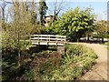
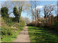
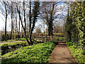
Bridge in Broadfield Park, Crawley
Over the Broadfield Book as it leaves the park.
Image: © Robin Webster
Taken: 24 Mar 2019
0.06 miles
5
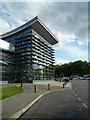
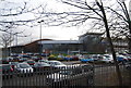
K2
This section of the building is an indoor climbing centre, hence the name.
Image: © Ian Capper
Taken: 3 May 2009
0.07 miles
6
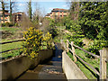
Lake spillway, Broadfield Park, Crawley
Broadfield Brook cascades down.
Image: © Robin Webster
Taken: 24 Mar 2019
0.07 miles
8
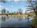
Lake and dam, Broadfield Park
Popular with anglers.
Image: © Robin Webster
Taken: 24 Mar 2019
0.08 miles