IMAGES TAKEN NEAR TO
Grouse Road, CRAWLEY, RH11 9AS
Introduction
This page details the photographs taken nearby to Grouse Road, RH11 9AS by members of the Geograph project.
The Geograph project started in 2005 with the aim of publishing, organising and preserving representative images for every square kilometre of Great Britain, Ireland and the Isle of Man.

There are currently over 7.5m images from over14,400 individuals and you can help contribute to the project by visiting https://www.geograph.org.uk
Image Map
Images are licensed for reuse under creativecommons.org/licenses/by-sa/2.0
Notes
- Clicking on the map will re-center to the selected point.
- The higher the marker number, the further away the image location is from the centre of the postcode.
Image Listing (6 Images Found)
Images are licensed for reuse under creativecommons.org/licenses/by-sa/2.0
Image
Details
Distance
2
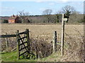
Bridleway changes direction
The cottages in the background are in the next grid square to the west.
Image: © Shazz
Taken: 25 Mar 2016
0.17 miles
3
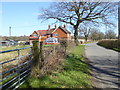
Shelley Cottages on Grouse Road
The radar station to the left of the dwellings is about half a mile away in grid square TQ2533.
Image: © Shazz
Taken: 25 Mar 2016
0.17 miles
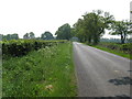
6
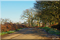
Grouse Road
A useful road for cyclists (and others) getting quickly away south from the Crawley urban sprawl.
Image: © Robin Webster
Taken: 4 Jan 2010
0.21 miles