IMAGES TAKEN NEAR TO
Lanercost Road, CRAWLEY, RH11 8YA
Introduction
This page details the photographs taken nearby to Lanercost Road, RH11 8YA by members of the Geograph project.
The Geograph project started in 2005 with the aim of publishing, organising and preserving representative images for every square kilometre of Great Britain, Ireland and the Isle of Man.

There are currently over 7.5m images from over14,400 individuals and you can help contribute to the project by visiting https://www.geograph.org.uk
Image Map
Images are licensed for reuse under creativecommons.org/licenses/by-sa/2.0
Notes
- Clicking on the map will re-center to the selected point.
- The higher the marker number, the further away the image location is from the centre of the postcode.
Image Listing (80 Images Found)
Images are licensed for reuse under creativecommons.org/licenses/by-sa/2.0
Image
Details
Distance
1
Lanercost Road, Southgate, Crawley
Built as urban infilling in the long back gardens of houses on Goffs Park Road.
Image: © Robin Webster
Taken: 11 Aug 2013
0.03 miles
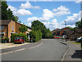
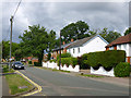
2
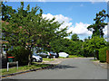
Roundabout on Perryfield Road, Southgate, Crawley
The road continues for a short distance to the right, but is a dead-end except on foot.
Image: © Robin Webster
Taken: 12 Aug 2013
0.06 miles
3
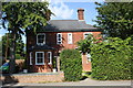
'Orleton Lodge', Goffs Park Road
There is an OS benchmark Image on the right hand side of the house near its front corner and behind shrubs
Image: © Roger Templeman
Taken: 19 Sep 2015
0.07 miles
4
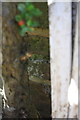
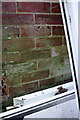
Benchmark behind shrub stems on #36 Goffs Park Road
Ordnance Survey cut mark benchmark described on the Bench Mark Database at http://www.bench-marks.org.uk/bm70687
Image: © Roger Templeman
Taken: 19 Sep 2015
0.07 miles
5
Malvern Road, Southgate, Crawley
Built as urban infilling in the long back gardens of houses on Goffs Park Road.
Image: © Robin Webster
Taken: 11 Aug 2013
0.07 miles
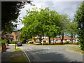
6
Keymer Road, Southgate, Crawley
This is urban infilling of long back gardens on Goffs Park Road. Some of the houses are of curious two storey plus design. The window arrangement suggests the tall part is not simply three storeys, but some sort of split level.
Image: © Robin Webster
Taken: 12 Aug 2013
0.08 miles
7
No. 18 and 16 Goffs Park Road
There is an OS benchmark Image on the side of the right hand house
Image: © Roger Templeman
Taken: 19 Sep 2015
0.09 miles
8
Benchmark on #16 Goffs Park Drive
Ordnance Survey cut mark benchmark described on the Bench Mark Database at http://www.bench-marks.org.uk/bm70400
Image: © Roger Templeman
Taken: 19 Sep 2015
0.09 miles
9
Houses on Perryfield Road, Southgate, Crawley
A dead-end road except on foot.
Image: © Robin Webster
Taken: 12 Aug 2013
0.10 miles
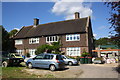
10
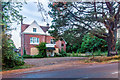
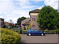
Former Goffs Park Nursing Home
Former nursing home in Goffs Park Road, housed in an Edwardian villa, dating from when Goffs Park Road started development. It was closed in 2015. Seen here in late evening light.
Image: © Ian Capper
Taken: 9 Aug 2018
0.10 miles