IMAGES TAKEN NEAR TO
Spring Close, CRAWLEY, RH11 8SZ
Introduction
This page details the photographs taken nearby to Spring Close, RH11 8SZ by members of the Geograph project.
The Geograph project started in 2005 with the aim of publishing, organising and preserving representative images for every square kilometre of Great Britain, Ireland and the Isle of Man.

There are currently over 7.5m images from over14,400 individuals and you can help contribute to the project by visiting https://www.geograph.org.uk
Image Map (Loading...)


Getting Data...Please wait
Leaflet Map data © OpenStreetMap
Images are licensed for reuse under creativecommons.org/licenses/by-sa/2.0
Notes
- Clicking on the map will re-center to the selected point.
- The higher the marker number, the further away the image location is from the centre of the postcode.
Image Listing (222 Images Found)
Images are licensed for reuse under creativecommons.org/licenses/by-sa/2.0
Image
Details
Distance
1
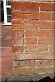
Benchmark on #10 Denne Road
Ordnance Survey cut mark benchmark described on the Bench Mark Database at http://www.bench-marks.org.uk/bm70389
Image: © Roger Templeman
Taken: 19 Sep 2015
0.03 miles
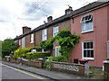
2
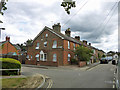
House on the corner, Southgate, Crawley
The corner of West Street and Denne Road to the left.
Image: © Robin Webster
Taken: 12 Aug 2013
0.03 miles
3
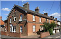
#10 Denne Road at West Street junction
There is an OS benchmark Image on the near corner, right hand face, of the house
Image: © Roger Templeman
Taken: 19 Sep 2015
0.03 miles
4
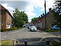
West Street, Southgate, Crawley
Viewed from the connection through to Newlands Road which is blocked for vehicles.
Image: © Robin Webster
Taken: 11 Aug 2013
0.04 miles
5
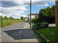
Springfield Road, Crawley
This runs closely parallel to the railway, over the weedy fence to the left, for its entire length.
Image: © Robin Webster
Taken: 11 Aug 2013
0.05 miles
6
Oak Road, Southgate, Crawley
No significant oaks in sight, the large tree at the end of the road appears to be a lime.
Image: © Robin Webster
Taken: 11 Aug 2013
0.06 miles
7
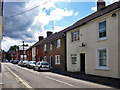
West Street, Crawley
In the older part of Crawley, pre-new town.
Image: © Robin Webster
Taken: 11 Aug 2013
0.07 miles
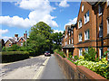
8
Houses on West Street, Southgate, Crawley
Mostly vying with each other on front garden greenery.
Image: © Robin Webster
Taken: 12 Aug 2013
0.07 miles
9
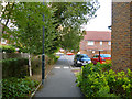
Path from Winter Gardens to Newlands Road, Southgate, Crawley
In an area of urban infilling.
Image: © Robin Webster
Taken: 11 Aug 2013
0.10 miles
10
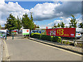
Asda, Crawley - pedestrian access from Spencers Road
The supermarket is at the far side of its car park.
Image: © Robin Webster
Taken: 11 Aug 2013
0.10 miles