IMAGES TAKEN NEAR TO
Ditchling Hill, CRAWLEY, RH11 8QL
Introduction
This page details the photographs taken nearby to Ditchling Hill, RH11 8QL by members of the Geograph project.
The Geograph project started in 2005 with the aim of publishing, organising and preserving representative images for every square kilometre of Great Britain, Ireland and the Isle of Man.

There are currently over 7.5m images from over14,400 individuals and you can help contribute to the project by visiting https://www.geograph.org.uk
Image Map
Images are licensed for reuse under creativecommons.org/licenses/by-sa/2.0
Notes
- Clicking on the map will re-center to the selected point.
- The higher the marker number, the further away the image location is from the centre of the postcode.
Image Listing (55 Images Found)
Images are licensed for reuse under creativecommons.org/licenses/by-sa/2.0
Image
Details
Distance
1
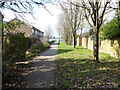
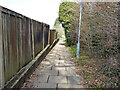
Path, Ditchling Hill, Southgate, Crawley
Actually on Hogs Hill, Ditchling Hill is a residential road that includes branching paths in its addresses.
Image: © Robin Webster
Taken: 7 Mar 2021
0.01 miles
2
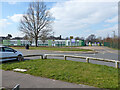
Hilltop Primary School, Southgate, Crawley
Image: © Robin Webster
Taken: 7 Mar 2021
0.04 miles
3
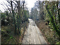
A2219 Brighton Road, Crawley
Towards Brighton, the original main London - Brighton route through Crawley, here passing through the ridge of Hogs Hill in a cutting.
Image: © Robin Webster
Taken: 7 Mar 2021
0.04 miles
4
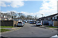
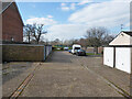
A branch of Ditchling Hill, Southgate, Crawley
Rear access to houses whose fronts are reached by paths only.
Image: © Robin Webster
Taken: 7 Mar 2021
0.05 miles
5
Garages, Rackham Close, Southgate, Crawley
Image: © Robin Webster
Taken: 7 Mar 2021
0.05 miles
6
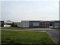
Hilltop Primary School
Primary school in Southgate West, Crawley. Formerly Southgate West First and Middle Schools from 1974sc to 2004.
Image: © Michael of Crawley
Taken: 6 Apr 2009
0.07 miles
7
A2219 Brighton Road, Crawley
Towards the town centre, the original main London - Brighton route through Crawley, here passing through the ridge of Hogs Hill in a cutting.
Image: © Robin Webster
Taken: 7 Mar 2021
0.08 miles
8
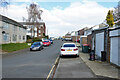
Caburn Heights, Southgate, Crawley
A branched road.
Image: © Robin Webster
Taken: 7 Mar 2021
0.08 miles
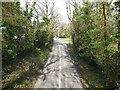
9
Path by Brighton Road, Southgate, Crawley
Parallel with the road, but following the natural ground contour, whereas the road to the right passes through the ridge here in a cutting with no footway.
Image: © Robin Webster
Taken: 7 Mar 2021
0.09 miles
10
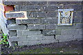
Benchmark on wall of Brighton Road at Southgate Drive junction
Ordnance Survey cut mark benchmark described on the Bench Mark Database at http://www.bench-marks.org.uk/bm70695
Image: © Roger Templeman
Taken: 19 Sep 2015
0.10 miles