IMAGES TAKEN NEAR TO
Manorfields, Sullivan Drive, CRAWLEY, RH11 8GN
Introduction
This page details the photographs taken nearby to Manorfields, Sullivan Drive, RH11 8GN by members of the Geograph project.
The Geograph project started in 2005 with the aim of publishing, organising and preserving representative images for every square kilometre of Great Britain, Ireland and the Isle of Man.

There are currently over 7.5m images from over14,400 individuals and you can help contribute to the project by visiting https://www.geograph.org.uk
Image Map
Images are licensed for reuse under creativecommons.org/licenses/by-sa/2.0
Notes
- Clicking on the map will re-center to the selected point.
- The higher the marker number, the further away the image location is from the centre of the postcode.
Image Listing (75 Images Found)
Images are licensed for reuse under creativecommons.org/licenses/by-sa/2.0
Image
Details
Distance
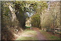
2
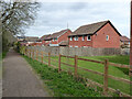
Houses on Manorfields, Bewbush, Crawley
Backing on to bridleway 1550.
Image: © Robin Webster
Taken: 27 Mar 2021
0.04 miles
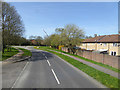
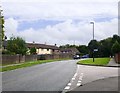
3
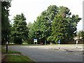
Roundabout on Sullivan Drive, Bewbush, Crawley
This is at a corner of Sullivan Drive, with no other roads off it.
Image: © Robin Webster
Taken: 22 Aug 2013
0.05 miles
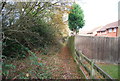
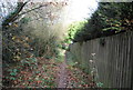
5
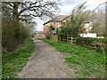
Bridleway 1550, Bewbush, Crawley
Along the west edge of Bewbush and Crawley Borough.
Image: © Robin Webster
Taken: 27 Mar 2021
0.07 miles
6
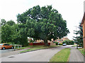
Large oak near Bewbush Manor House, Crawley
The car park for the manor house is on the left, the tree was doubtless in its immediate grounds originally.
Image: © Robin Webster
Taken: 22 Aug 2013
0.07 miles
10
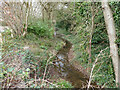
Spruce Hill Brook where it forms a moat, Bewbush, Crawley
Looking north, downstream, where it forms the two remaining wet sides of the partially dewatered moat around Bewbush Manor. The moated site is a Scheduled Ancient Monument. Note that the Historic England description has the stream flow back to front.
Image: © Robin Webster
Taken: 27 Mar 2021
0.09 miles