IMAGES TAKEN NEAR TO
Kennet Close, CRAWLEY, RH11 8DH
Introduction
This page details the photographs taken nearby to Kennet Close, RH11 8DH by members of the Geograph project.
The Geograph project started in 2005 with the aim of publishing, organising and preserving representative images for every square kilometre of Great Britain, Ireland and the Isle of Man.

There are currently over 7.5m images from over14,400 individuals and you can help contribute to the project by visiting https://www.geograph.org.uk
Image Map (Loading...)


Getting Data...Please wait
Leaflet Map data © OpenStreetMap
Images are licensed for reuse under creativecommons.org/licenses/by-sa/2.0
Notes
- Clicking on the map will re-center to the selected point.
- The higher the marker number, the further away the image location is from the centre of the postcode.
Image Listing (93 Images Found)
Images are licensed for reuse under creativecommons.org/licenses/by-sa/2.0
Image
Details
Distance
1
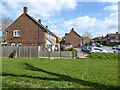
Houses on Derwent Close, Gossops Green
The brick buttress on the left is odd, not the usual way of propping up a wooden fence. There was nothing mapped there from before the New Town.
Image: © Robin Webster
Taken: 21 Mar 2021
0.07 miles
2
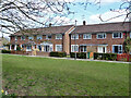
Houses on Lea Close, Gossops Green, Crawley
Image: © Robin Webster
Taken: 21 Mar 2021
0.07 miles
3
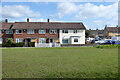
Houses on Lea Close, Gossops Green, Crawley
Image: © Robin Webster
Taken: 21 Mar 2021
0.07 miles
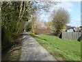
4
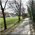
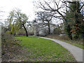
Path along bank of Ifield Mill Pond, Gossops Green, Crawley
The pond is on the right, only intermittently clearly visible through the vegetation along this stretch.
Image: © Robin Webster
Taken: 21 Mar 2021
0.09 miles
5
Path along bank of Ifield Mill Pond, Gossops Green, Crawley
The pond is on the left, some way down from the top of the bank, which appears to be a precautionary flood defence.
Image: © Robin Webster
Taken: 21 Mar 2021
0.10 miles
6
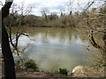
Ifield Mill Pond, Gossops Green, Crawley
The railway runs on an embankment at the far side, it cut the mill pond in two, with just a single arch communication. This side is larger.
Image: © Robin Webster
Taken: 21 Mar 2021
0.11 miles
7
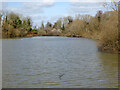
Ifield Mill Pond, Crawley
The north end of the part south of the railway, on the Gossops Green side.
Image: © Robin Webster
Taken: 21 Mar 2021
0.11 miles
8
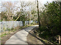
Path towards The Hollow, Gossops Green, Crawley
From Ifield Mill Pond, the railway is on the left.
Image: © Robin Webster
Taken: 21 Mar 2021
0.12 miles
9
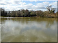
Ifield Mill Pond, Gossops Green, Crawley
The railway on an embankment cut the mill pond in two, with just a single arch communication. This side is much larger.
Image: © Robin Webster
Taken: 21 Mar 2021
0.12 miles
10
Path to Ifield Mill Pond, Gossops Green, Crawley
The railway is on the right.
Image: © Robin Webster
Taken: 21 Mar 2021
0.12 miles