IMAGES TAKEN NEAR TO
Delrogue Road, CRAWLEY, RH11 7GG
Introduction
This page details the photographs taken nearby to Delrogue Road, RH11 7GG by members of the Geograph project.
The Geograph project started in 2005 with the aim of publishing, organising and preserving representative images for every square kilometre of Great Britain, Ireland and the Isle of Man.

There are currently over 7.5m images from over14,400 individuals and you can help contribute to the project by visiting https://www.geograph.org.uk
Image Map
Images are licensed for reuse under creativecommons.org/licenses/by-sa/2.0
Notes
- Clicking on the map will re-center to the selected point.
- The higher the marker number, the further away the image location is from the centre of the postcode.
Image Listing (27 Images Found)
Images are licensed for reuse under creativecommons.org/licenses/by-sa/2.0
Image
Details
Distance
1
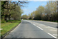
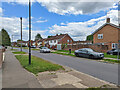
Ifield Avenue, Crawley
Ifield neighbourhood on the left, Langley Green on the right.
Image: © Robin Webster
Taken: 4 Apr 2021
0.04 miles
2
Ifield Avenue, Crawley
Ifield neighbourhood on the left, Langley Green on the right.
Image: © Robin Webster
Taken: 4 Apr 2021
0.05 miles
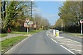
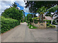
3
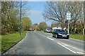
East end of Langley Lane, Ifield, Crawley
Langley Lane was one of the old through routes of the area. It is a public bridleway 1525, but with a lot of property access, from the Ifield Green end only.
Image: © Robin Webster
Taken: 28 May 2022
0.07 miles
4
Ifield Avenue, Crawley
Ifield neighbourhood on the left, Langley Green on the right.
Image: © Robin Webster
Taken: 4 Apr 2021
0.10 miles
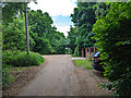
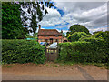
5
House, Langley Lane, Ifield, Crawley
Langley Lane was one of the old routes of the area. It is public bridleway 1525, but with a lot of property access, from Ifield Green only.
Image: © Robin Webster
Taken: 28 May 2022
0.10 miles
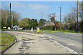
6
Rushetts Road, Langley Green, Crawley
Image: © Robin Webster
Taken: 28 May 2022
0.12 miles
7
Ifield Avenue, Crawley
Ifield neighbourhood on the left, Langley Green on the right.
Image: © Robin Webster
Taken: 4 Apr 2021
0.13 miles
8
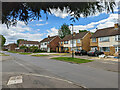
Houses, Rushetts Road, Langley Green, Crawley
Image: © Robin Webster
Taken: 28 May 2022
0.14 miles
9
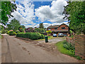
Old Inn Cottage, Langley Lane, Ifield, Crawley
About 1600, grade II listed.
Image: © Robin Webster
Taken: 28 May 2022
0.14 miles
10
Langley Lane, Ifield, Crawley
Langley Lane was one of the old routes of the area. It is public bridleway 1525, but with a lot of property access, from Ifield Green only.
Image: © Robin Webster
Taken: 28 May 2022
0.15 miles