IMAGES TAKEN NEAR TO
Milne Close, CRAWLEY, RH11 6AS
Introduction
This page details the photographs taken nearby to Milne Close, RH11 6AS by members of the Geograph project.
The Geograph project started in 2005 with the aim of publishing, organising and preserving representative images for every square kilometre of Great Britain, Ireland and the Isle of Man.

There are currently over 7.5m images from over14,400 individuals and you can help contribute to the project by visiting https://www.geograph.org.uk
Image Map
Images are licensed for reuse under creativecommons.org/licenses/by-sa/2.0
Notes
- Clicking on the map will re-center to the selected point.
- The higher the marker number, the further away the image location is from the centre of the postcode.
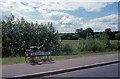
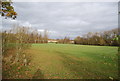
Image Listing (66 Images Found)
Images are licensed for reuse under creativecommons.org/licenses/by-sa/2.0
Image
Details
Distance
1
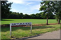
Road name sign for Arcturus Road (2019)
To see a similar photo taken 30 years previously see Image
Image: © Barry Shimmon
Taken: 24 Aug 2019
0.03 miles
4
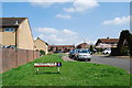
Callisto Close in 2018
To see a photo taken here in 1989 see Image
Image: © Barry Shimmon
Taken: 14 Apr 2018
0.06 miles
10
Ganymede Court in 2018
To see a photo taken here in 1989 see Image
Image: © Barry Shimmon
Taken: 14 Apr 2018
0.08 miles