IMAGES TAKEN NEAR TO
Shearwater Court, CRAWLEY, RH11 0SH
Introduction
This page details the photographs taken nearby to Shearwater Court, RH11 0SH by members of the Geograph project.
The Geograph project started in 2005 with the aim of publishing, organising and preserving representative images for every square kilometre of Great Britain, Ireland and the Isle of Man.

There are currently over 7.5m images from over14,400 individuals and you can help contribute to the project by visiting https://www.geograph.org.uk
Image Map
Images are licensed for reuse under creativecommons.org/licenses/by-sa/2.0
Notes
- Clicking on the map will re-center to the selected point.
- The higher the marker number, the further away the image location is from the centre of the postcode.
Image Listing (78 Images Found)
Images are licensed for reuse under creativecommons.org/licenses/by-sa/2.0
Image
Details
Distance
2
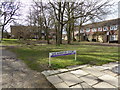
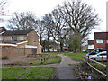
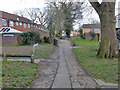
Looking west on Stoneycroft Walk
Stoneycroft Walk is a public footpath.
Image: © Shazz
Taken: 28 Mar 2016
0.02 miles
3
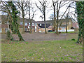
Dry pond, Shearwater Court, Ifield, Crawley
Image: © Robin Webster
Taken: 21 Mar 2021
0.02 miles

7
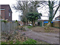
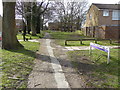
Path north to Fairway, Ifield, Crawley
From Stoneycroft Walk.
Image: © Robin Webster
Taken: 21 Mar 2021
0.04 miles
10
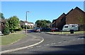
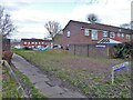
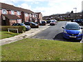
Tern Road, Ifield West, Crawley, West Sussex - 1980/90 housing.
Ifield West was one of the later neighbourhoods to be built in Crawley, on its extreme western side. Of typically modern style the packing density of the houses appears to be greater than many of the original neighbourhoods.
Image: © Pete Chapman
Taken: 14 Jul 2005
0.05 miles