IMAGES TAKEN NEAR TO
Poles Lane, CRAWLEY, RH11 0PX
Introduction
This page details the photographs taken nearby to Poles Lane, RH11 0PX by members of the Geograph project.
The Geograph project started in 2005 with the aim of publishing, organising and preserving representative images for every square kilometre of Great Britain, Ireland and the Isle of Man.

There are currently over 7.5m images from over14,400 individuals and you can help contribute to the project by visiting https://www.geograph.org.uk
Image Map
Images are licensed for reuse under creativecommons.org/licenses/by-sa/2.0
Notes
- Clicking on the map will re-center to the selected point.
- The higher the marker number, the further away the image location is from the centre of the postcode.
Image Listing (15 Images Found)
Images are licensed for reuse under creativecommons.org/licenses/by-sa/2.0
Image
Details
Distance
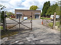
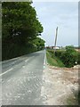
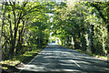
2
Poles Lane
A public bridleway but surfaced for vehicle access.
Image: © Robin Webster
Taken: 30 Jun 2015
0.13 miles
3
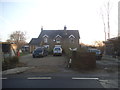
House on Charlwood Road, Lowfield Heath
Image: © David Howard
Taken: 22 Jan 2017
0.17 miles
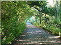
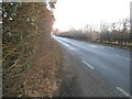
5
Charlwood Road
The high hedge on the left conceals Gatwick Airport. You can make out the spire of Image in the distance.
Image: © Martyn Davies
Taken: 15 May 2006
0.20 miles
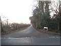
6
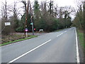
Road Junction, Lowfield Heath
This is a junction between Charlwood Road and Poles Lane. To the left is Gatwick Kennels and Cattery.
Image: © Lorraine and Keith Bowdler
Taken: 28 Mar 2010
0.20 miles
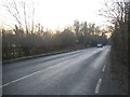
9
Charlwood Road towards Charlwood
Skirting Gatwick Airport to the right and approaching a slightly humped bridge over the River Mole.
Image: © Robin Webster
Taken: 4 Nov 2022
0.21 miles
10
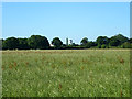
Field near Gatwick Airport
The control tower may be seen across the hedges.
Image: © Robin Webster
Taken: 30 Jun 2015
0.22 miles