IMAGES TAKEN NEAR TO
Hightrees, CRAWLEY, RH11 0EZ
Introduction
This page details the photographs taken nearby to Hightrees, RH11 0EZ by members of the Geograph project.
The Geograph project started in 2005 with the aim of publishing, organising and preserving representative images for every square kilometre of Great Britain, Ireland and the Isle of Man.

There are currently over 7.5m images from over14,400 individuals and you can help contribute to the project by visiting https://www.geograph.org.uk
Image Map
Images are licensed for reuse under creativecommons.org/licenses/by-sa/2.0
Notes
- Clicking on the map will re-center to the selected point.
- The higher the marker number, the further away the image location is from the centre of the postcode.
Image Listing (116 Images Found)
Images are licensed for reuse under creativecommons.org/licenses/by-sa/2.0
Image
Details
Distance
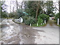
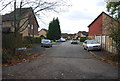
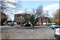
5
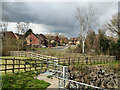
Housing estate accessed via Guinevere Road, Ifield
Viewed over the high level spillway from Ifield Mill Pond.
Image: © Robin Webster
Taken: 2 Apr 2022
0.09 miles
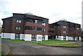
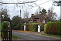
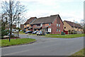
8
Camelot Court, Ifield, Crawley
Flats.
Image: © Robin Webster
Taken: 21 Mar 2021
0.11 miles
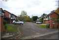
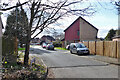
9
Houses on Guinevere Road, Ifield, Crawley
Image: © Robin Webster
Taken: 21 Mar 2021
0.12 miles