IMAGES TAKEN NEAR TO
Crawley Avenue, CRAWLEY, RH11 0DB
Introduction
This page details the photographs taken nearby to Crawley Avenue, RH11 0DB by members of the Geograph project.
The Geograph project started in 2005 with the aim of publishing, organising and preserving representative images for every square kilometre of Great Britain, Ireland and the Isle of Man.

There are currently over 7.5m images from over14,400 individuals and you can help contribute to the project by visiting https://www.geograph.org.uk
Image Map (Loading...)


Getting Data...Please wait
Leaflet Map data © OpenStreetMap
Images are licensed for reuse under creativecommons.org/licenses/by-sa/2.0
Notes
- Clicking on the map will re-center to the selected point.
- The higher the marker number, the further away the image location is from the centre of the postcode.
Image Listing (47 Images Found)
Images are licensed for reuse under creativecommons.org/licenses/by-sa/2.0
Image
Details
Distance
1
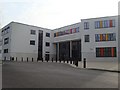
Ifield Community College
Main entrance of secondary school for 11 to 18-year-olds. Opened in current building in 2005, following move from former site on the same campus.
Image: © Michael of Crawley
Taken: 6 Apr 2009
0.01 miles
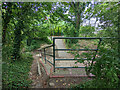
2
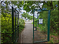
Ifield Community College - entrance from footpath 1543
Image: © Robin Webster
Taken: 28 May 2022
0.05 miles
3
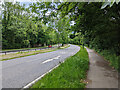
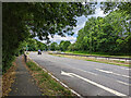
A23 Crawley Avenue, Crawley
There are foot/cycle paths to each side of the dual carriageway.
Image: © Robin Webster
Taken: 28 May 2022
0.06 miles
4
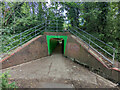
Subway under A23, Crawley
Footpath 1543 passes through, from Ifield Drive, Ifield to The Dingle, West Green. There is no official connection to the path along the A23, but there is evidently traffic. The handrail is a great help.
Image: © Robin Webster
Taken: 28 May 2022
0.06 miles
5
Subway under A23, Crawley
Looking from the path along the A23. There is no official connection between the two, but there is evidently traffic. The handrail is a great help.
Image: © Robin Webster
Taken: 28 May 2022
0.06 miles
6
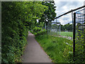
Public footpath 1543, Crawley
From The Dingle, West Green, to Ifield Drive, Ifield. Here it skirts around the playing fields of Ifield Community College.
Image: © Robin Webster
Taken: 28 May 2022
0.08 miles
7
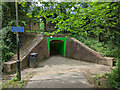
Subway under A23, Crawley
Footpath 1543 passes through, from The Dingle, West Green, to Ifield Drive, Ifield. There is no official connection to the path along the A23, but there is evidently traffic.
Image: © Robin Webster
Taken: 28 May 2022
0.08 miles
8
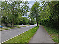
A23 Crawley Avenue, Crawley
There are foot/cycle paths to each side of the dual carriageway.
Image: © Robin Webster
Taken: 28 May 2022
0.09 miles
9
A23 Crawley Avenue, Crawley
There are foot/cycle paths to each side of the dual carriageway.
Image: © Robin Webster
Taken: 28 May 2022
0.10 miles
10
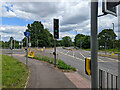
Turning off A23 for Ifield Community College, Crawley
Image: © Robin Webster
Taken: 28 May 2022
0.11 miles