IMAGES TAKEN NEAR TO
Ardingly Close, CRAWLEY, RH11 0AA
Introduction
This page details the photographs taken nearby to Ardingly Close, RH11 0AA by members of the Geograph project.
The Geograph project started in 2005 with the aim of publishing, organising and preserving representative images for every square kilometre of Great Britain, Ireland and the Isle of Man.

There are currently over 7.5m images from over14,400 individuals and you can help contribute to the project by visiting https://www.geograph.org.uk
Image Map
Images are licensed for reuse under creativecommons.org/licenses/by-sa/2.0
Notes
- Clicking on the map will re-center to the selected point.
- The higher the marker number, the further away the image location is from the centre of the postcode.
Image Listing (54 Images Found)
Images are licensed for reuse under creativecommons.org/licenses/by-sa/2.0
Image
Details
Distance
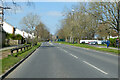
1
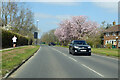
Ifield Avenue, Crawley
Ifield neighbourhood on the left, Langley Green on the right.
Image: © Robin Webster
Taken: 4 Apr 2021
0.03 miles
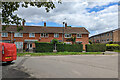
2
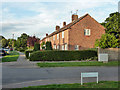
Houses on Nightingale Close, Langley Green, Crawley
The 'Close' is the road on the left, which is only really a close behind the camera, as there is a through route back to Maiden Lane via Lark Rise in the foreground.
Image: © Robin Webster
Taken: 30 Aug 2013
0.06 miles
3
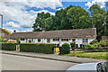
Cottages, Climping Road, Ifield, Crawley
Where 'cottage' = 'small single storey housing for the elderly'.
Image: © Robin Webster
Taken: 28 May 2022
0.09 miles
4
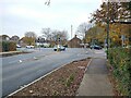
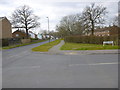
New signal controlled junction replaces mini roundabout
In October/November 2021 the mini roundabout at Ifield Drive / Ifield Avenue was replaced by a traffic signal controlled junction. This junction also replaced a standalone Toucan crossing to the South.
All sides of the new junction have Toucan crossings and an all-green pedestrian stage. Some approaches were also widened to two lanes and improvements to the bus stop on the Northern side.
Image: © Thoma
Taken: 19 Nov 2021
0.09 miles
5
Houses, Climping Road, Ifield, Crawley
Image: © Robin Webster
Taken: 28 May 2022
0.10 miles
6
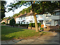
Houses, Lark Rise, Langley Green, Crawley
On a walk between the road part of Lark Rise and Ifield Avenue.
Image: © Robin Webster
Taken: 30 Aug 2013
0.10 miles
7
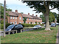
Houses on Lark Rise, Langley Green, Crawley
The names of the lesser roads in this area have a bird theme.
Image: © Robin Webster
Taken: 1 Sep 2013
0.10 miles
8
Ifield Avenue, Crawley
Ifield neighbourhood on the left, Langley Green on the right.
Image: © Robin Webster
Taken: 4 Apr 2021
0.10 miles
10
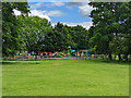
Playground, Ewhurst Playing Field, Ifield, Crawley
Image: © Robin Webster
Taken: 28 May 2022
0.12 miles