IMAGES TAKEN NEAR TO
Fleming Centre, Fleming Way, CRAWLEY, RH10 9NN
Introduction
This page details the photographs taken nearby to Fleming Centre, Fleming Way, RH10 9NN by members of the Geograph project.
The Geograph project started in 2005 with the aim of publishing, organising and preserving representative images for every square kilometre of Great Britain, Ireland and the Isle of Man.

There are currently over 7.5m images from over14,400 individuals and you can help contribute to the project by visiting https://www.geograph.org.uk
Image Map (Loading...)


Getting Data...Please wait
Leaflet Map data © OpenStreetMap
Images are licensed for reuse under creativecommons.org/licenses/by-sa/2.0
Notes
- Clicking on the map will re-center to the selected point.
- The higher the marker number, the further away the image location is from the centre of the postcode.
Image Listing (35 Images Found)
Images are licensed for reuse under creativecommons.org/licenses/by-sa/2.0
Image
Details
Distance
1
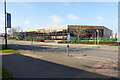
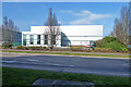
The Fleming Centre - Chemigraphic, Fleming Way, Crawley
There other businesses on the site, but Chemigraphic dominates the frontage. They are electronic product manufacturers.
Image: © Robin Webster
Taken: 28 Feb 2021
0.08 miles
2
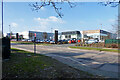
Hyundai dealers, Fleming Way, Crawley
Image: © Robin Webster
Taken: 28 Feb 2021
0.09 miles
3
Hydehurst Lane, Crawley
A dead-end, with a Tesco depot on the right.
Image: © Robin Webster
Taken: 28 Feb 2021
0.12 miles
4
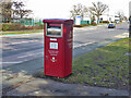
Parcel post box for pre-paid items, Fleming Way, Manor Royal, Crawley
Box number RH10 150P.
Image: © Robin Webster
Taken: 13 Mar 2021
0.12 miles
5
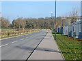
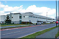
Industrial warehouse unit to let, Fleming Way, Crawley
Image: © Robin Webster
Taken: 28 Feb 2021
0.12 miles
6
Virgin Atlantic, Fleming Way, Manor Royal zone 2, Crawley
The airline Virgin.
Image: © Robin Webster
Taken: 13 Mar 2021
0.13 miles
7
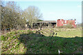
Derelict barns, former Windyridge Farm
North of Hydehurst Lane. 'Windyridge' seems a rather inappropriate name as far as the ridge bit goes.
Image: © Robin Webster
Taken: 28 Feb 2021
0.13 miles
8
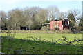
Derelict buildings, former Windyridge Farm
North of Hydehurst Lane. 'Windyridge' seems a rather inappropriate name, as far as the ridge bit goes.
Image: © Robin Webster
Taken: 28 Feb 2021
0.13 miles
9
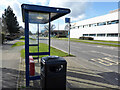
Fleming Way West bus stop, Manor Royal, Crawley
For route 10 towards the town centre.
Image: © Robin Webster
Taken: 13 Mar 2021
0.15 miles
10
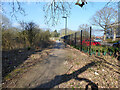
Public footpath 1528 to Rowley Farm
The route here has altered somewhat from what it was as the Crawley industrial area has grown northwards.
Image: © Robin Webster
Taken: 28 Feb 2021
0.15 miles