IMAGES TAKEN NEAR TO
Gatwick Road, CRAWLEY, RH10 9BF
Introduction
This page details the photographs taken nearby to Gatwick Road, RH10 9BF by members of the Geograph project.
The Geograph project started in 2005 with the aim of publishing, organising and preserving representative images for every square kilometre of Great Britain, Ireland and the Isle of Man.

There are currently over 7.5m images from over14,400 individuals and you can help contribute to the project by visiting https://www.geograph.org.uk
Image Map
Images are licensed for reuse under creativecommons.org/licenses/by-sa/2.0
Notes
- Clicking on the map will re-center to the selected point.
- The higher the marker number, the further away the image location is from the centre of the postcode.
Image Listing (59 Images Found)
Images are licensed for reuse under creativecommons.org/licenses/by-sa/2.0
Image
Details
Distance
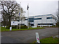
2
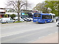
Gatwick Road, Manor Royal, Crawley
Approaching the northern end of the Crawley business district, apart from Gatwick.
Image: © Robin Webster
Taken: 23 Mar 2019
0.04 miles
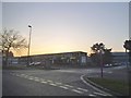
4
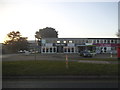
The Gatwick School
A school opened in autumn 2014, oddly located in the Crawley business district.
Image: © Robin Webster
Taken: 1 Jan 2015
0.05 miles
5
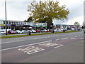
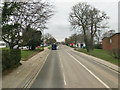
Tree in front of retail outlets on Gatwick Road
Image: © Shazz
Taken: 30 Apr 2016
0.05 miles
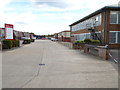
8
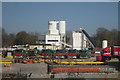
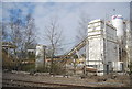
Lorries at Crawley industrial Estate
Image: © Oast House Archive
Taken: 17 Apr 2010
0.15 miles
9
A glimpse of the railway, Forge Wood
I waited for a train, but none came.
Image: © Robin Webster
Taken: 2 Oct 2022
0.15 miles