IMAGES TAKEN NEAR TO
Woolborough Lane, CRAWLEY, RH10 9AQ
Introduction
This page details the photographs taken nearby to Woolborough Lane, RH10 9AQ by members of the Geograph project.
The Geograph project started in 2005 with the aim of publishing, organising and preserving representative images for every square kilometre of Great Britain, Ireland and the Isle of Man.

There are currently over 7.5m images from over14,400 individuals and you can help contribute to the project by visiting https://www.geograph.org.uk
Image Map
Images are licensed for reuse under creativecommons.org/licenses/by-sa/2.0
Notes
- Clicking on the map will re-center to the selected point.
- The higher the marker number, the further away the image location is from the centre of the postcode.
Image Listing (56 Images Found)
Images are licensed for reuse under creativecommons.org/licenses/by-sa/2.0
Image
Details
Distance
1
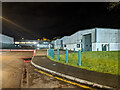
Units B1 - B4, Woolborough Lane, Industrial Zone 3, Crawley
Image: © Robin Webster
Taken: 3 Feb 2021
0.02 miles
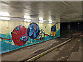
2
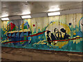
Art under A2011 Crawley Avenue
In the Woolborough Lane subway.
Image: © Robin Webster
Taken: 3 Feb 2021
0.04 miles
3
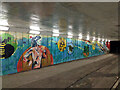
Art under A2011 Crawley Avenue
In the Woolborough Lane subway.
Image: © Robin Webster
Taken: 3 Feb 2021
0.05 miles
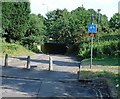
4
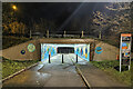
Woolborough Lane passes under A2011 Crawley Avenue
Here reduced to foot and cycle only. A way from where people live to where they work.
Image: © Robin Webster
Taken: 3 Feb 2021
0.05 miles
5
Art under A2011 Crawley Avenue
In the Woolborough Lane subway.
Image: © Robin Webster
Taken: 3 Feb 2021
0.05 miles
6
Cycle Subway (on National Cycle Network Route 20) between Manor Royal Industrial Estate and Northgate, Crawley, West Sussex
National Cycle Network route 20 passes through Crawley. Here we see where the cycle path is routed under the main Crawley dual carriageway inner bypass. NCN 20 is a route from London to Brighton.
Image: © Pete Chapman
Taken: 7 Jul 2005
0.06 miles
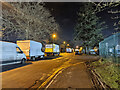
7
Woolborough Lane, Industrial Zone 3, Crawley
A lot of vehicles parked here, many overspill from the Hermes parcels depot on the left.
Image: © Robin Webster
Taken: 3 Feb 2021
0.07 miles
8
Woolborough Lane, Industrial Zone 3, Crawley
A lot of vehicles parked here, many overspill from the Hermes parcels depot on the right.
Image: © Robin Webster
Taken: 3 Feb 2021
0.08 miles
9
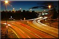
Rush Hour traffic
Taken from the bridge over the A264, close to Hazelwick School, looking west.
Image: © CDSnapper
Taken: 17 Oct 2007
0.08 miles
10
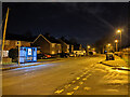
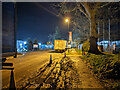
Woodfield Road, Northgate, Crawley
Towards the town centre, the bus stop is Woolborough Lane, served by route 100.
Image: © Robin Webster
Taken: 3 Feb 2021
0.10 miles