IMAGES TAKEN NEAR TO
Baxter Close, Fenchurch Road, CRAWLEY, RH10 7XE
Introduction
This page details the photographs taken nearby to Baxter Close, Fenchurch Road, RH10 7XE by members of the Geograph project.
The Geograph project started in 2005 with the aim of publishing, organising and preserving representative images for every square kilometre of Great Britain, Ireland and the Isle of Man.

There are currently over 7.5m images from over14,400 individuals and you can help contribute to the project by visiting https://www.geograph.org.uk
Image Map
Images are licensed for reuse under creativecommons.org/licenses/by-sa/2.0
Notes
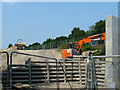
- Clicking on the map will re-center to the selected point.
- The higher the marker number, the further away the image location is from the centre of the postcode.
Image Listing (83 Images Found)
Images are licensed for reuse under creativecommons.org/licenses/by-sa/2.0
Image
Details
Distance
1
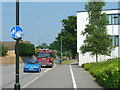
Fire engine at Oriel High School
It seemed to me a genuine call-out, but evidently of no large consequence.
Image: © Robin Webster
Taken: 7 Jul 2013
0.02 miles
2
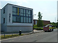
Fire engine at Oriel High School
It seemed to me a genuine call-out, but evidently of no large consequence.
Image: © Robin Webster
Taken: 7 Jul 2013
0.02 miles
4
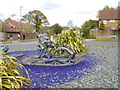
Sculpture on roundabout
It must depict some sort of insect.
Image: © Shazz
Taken: 30 Apr 2016
0.08 miles
5
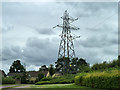
Pylon PYA 3
Although the '3' is discernible on the identity plate, the 'PYA' is not. This was obtained from plates in better condition further along the route. The three conductors for PYA start at Three Bridges Main substation, but are hung on the east side of PYB pylons as far as PYB 5. They then angle away to pylon PYA 2, where they are still hung on one side of the pylon, the other side being empty. Between PYA 2 and PYA 3 they are rearranged into a two and one configuration, as seen here. This continues for the rest of the line. It is interesting that there is no pylon PYA 1, presumably PYB 5 notionally standing in its place. This route is believed to be operated by UK Power Networks now.
Image: © Robin Webster
Taken: 5 Jul 2014
0.10 miles
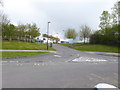
7
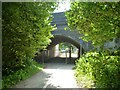
Railway bridge VTB3 129
Work on the extension of the bridge on the far side is in hand with a new concrete span in place, and now the widened embankment needs forming, hence the restricted width of the bridleway. The work is to accommodate additional sidings for stabling of stock for longer trains on the Thameslink service.
Image: © Robin Webster
Taken: 7 Jul 2013
0.10 miles
8
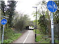
Path heads towards way under rail bridge
A view the other way from 2012 is at http://www.geograph.org.uk/photo/3179173.
Image: © Shazz
Taken: 30 Apr 2016
0.11 miles
9
Embankment widening south of Three Bridges
Extra sidings for twelve car Thameslink trains are being installed, which requires the embankment to be widened.
Image: © Robin Webster
Taken: 7 Jul 2013
0.11 miles
10
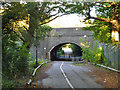
Railway bridge VTB3 129
A skew crossing of Maidenbower Lane, here only a bridleway, for four tracks. Network Rail has under construction facilities for servicing Thameslink trains in 12-car formations, which involve adding a further track across the lane on this side, with the new span abutting the existing bridge. The span will be of flat concrete beam construction, obscuring the existing arch profile beyond. It will be a generous 7 m wide transverse to the railway, so adding somewhat more to the lane cover. There will be lighting.
Image: © Robin Webster
Taken: 14 Oct 2012
0.11 miles