IMAGES TAKEN NEAR TO
Temple Close, CRAWLEY, RH10 7WW
Introduction
This page details the photographs taken nearby to Temple Close, RH10 7WW by members of the Geograph project.
The Geograph project started in 2005 with the aim of publishing, organising and preserving representative images for every square kilometre of Great Britain, Ireland and the Isle of Man.

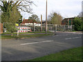
There are currently over 7.5m images from over14,400 individuals and you can help contribute to the project by visiting https://www.geograph.org.uk
Image Map
Images are licensed for reuse under creativecommons.org/licenses/by-sa/2.0
Notes
- Clicking on the map will re-center to the selected point.
- The higher the marker number, the further away the image location is from the centre of the postcode.
Image Listing (113 Images Found)
Images are licensed for reuse under creativecommons.org/licenses/by-sa/2.0
Image
Details
Distance
1
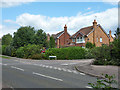
Maidenbower Drive - Redgrave Drive junction, Maidenbower, Crawley
Maidenbower Drive is one of the main routes through the Maidenbower neighbourhood, the rest is a bit of a maze.
Image: © Robin Webster
Taken: 10 Aug 2013
0.03 miles
2
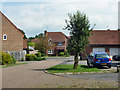
Sheldon Close, Maidenbower, Crawley
Looking from the end of one of the branches off Bancroft Road.
Image: © Robin Webster
Taken: 8 Aug 2013
0.05 miles
3
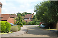
Parker Close, Maidenbower, Crawley
Looking from the end of one of the branches off Bancroft Road.
Image: © Robin Webster
Taken: 8 Aug 2013
0.05 miles
4
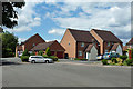
Houses, Bancroft Road, Maidenbower, Crawley
This is at the end of the road, with a foot connection to the path along the bank of the Gatwick Stream.
Image: © Robin Webster
Taken: 10 Aug 2013
0.06 miles
5
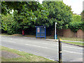
Laud Drive bus stop, Maidenbower, Crawley
Served by Metrobus route 100, which takes a large loop around the Maidenbower neighbourhood, so passes here only left to right. There is a bus stop across the road, but that is for school services only.
Image: © Robin Webster
Taken: 10 Aug 2013
0.07 miles
6
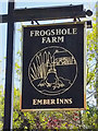
Inn sign, Frogshole Farm
For the inn, see Image
Image: © Robin Webster
Taken: 26 Apr 2020
0.07 miles
7
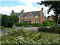
House on the corner, Maidenbower, Crawley
The corner of Collingwood Road and Redgrave Drive.
Image: © Robin Webster
Taken: 10 Aug 2013
0.09 miles
8
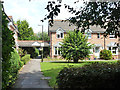
Housing, Clifton Road, Maidenbower, Crawley
The actual road is at the end of the path. The houses are back to front, facing away from the road.
Image: © Robin Webster
Taken: 8 Aug 2013
0.09 miles
9
Frogshole Farm after a Fire
Originally a farmhouse, latterly a pub, the site is cordoned off after a fire on 8 Feb 2007. Outwardly in good shape, according to the newspaper report about 50% was damaged and the roof of the kitchen collapsed.
Image: © Robin Webster
Taken: 14 Feb 2007
0.09 miles
10
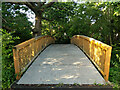
Bridge over Gatwick Stream, Maidenbower, Crawley
A way into school grounds, gated behind the camera.
Image: © Robin Webster
Taken: 6 Jul 2021
0.10 miles