IMAGES TAKEN NEAR TO
Parnell Close, CRAWLEY, RH10 7QZ
Introduction
This page details the photographs taken nearby to Parnell Close, RH10 7QZ by members of the Geograph project.
The Geograph project started in 2005 with the aim of publishing, organising and preserving representative images for every square kilometre of Great Britain, Ireland and the Isle of Man.

There are currently over 7.5m images from over14,400 individuals and you can help contribute to the project by visiting https://www.geograph.org.uk
Image Map (Loading...)


Getting Data...Please wait
Leaflet Map data © OpenStreetMap
Images are licensed for reuse under creativecommons.org/licenses/by-sa/2.0
Notes
- Clicking on the map will re-center to the selected point.
- The higher the marker number, the further away the image location is from the centre of the postcode.
Image Listing (88 Images Found)
Images are licensed for reuse under creativecommons.org/licenses/by-sa/2.0
Image
Details
Distance
1
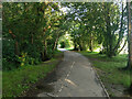
Path from Maidenbower Drive to Lucerne Drive, Maidenbower, Crawley
Along the north side of the recreation ground, following a stream with no apparent name.
Image: © Robin Webster
Taken: 6 Jul 2021
0.04 miles
2
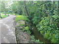
Stream along north side of recreation ground, Maidenbower
With no apparent name, but significant enough to have flooded and closed the M23 a while back - see Image It runs into Stanford Brook and thence to the Gatwick Stream.
Image: © Robin Webster
Taken: 6 Jul 2021
0.04 miles
3
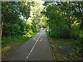
Path from Maidenbower Drive to Lucerne Drive, Maidenbower, Crawley
Along the north side of the recreation ground, following a stream with no apparent name.
Image: © Robin Webster
Taken: 6 Jul 2021
0.05 miles
4
Flats on Townsend Way, Maidenbower, Crawley
For a view of these in 2007, see Image
Image: © Robin Webster
Taken: 6 Jul 2021
0.06 miles
5
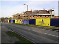
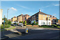
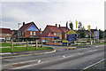
Parkside Development, Maidenbower, Crawley
This development will just about complete available sites in this area of Crawley. 2, 3, 4, and 5 bedroom houses are announced on the placards. The road is Lucerne Drive.
Image: © Robin Webster
Taken: 14 Feb 2007
0.06 miles
6
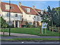
Houses, Parkside, Maidenbower, Crawley
Image: © Robin Webster
Taken: 6 Jul 2021
0.07 miles
7
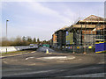
Townsend Way and housing construction, Maidenbower
Looking from Lucerne Drive.
Image: © Robin Webster
Taken: 14 Feb 2007
0.07 miles
8
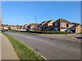
Maidenbower Drive, Maidenbower, Crawley
A principal road of the neighbourhood, on the 100 bus route.
Image: © Robin Webster
Taken: 2 Mar 2023
0.08 miles
9

Junction of Lawrence Close and Lucerne Drive, Maidenbower
For a view of this corner in 2007, see Image
Image: © Robin Webster
Taken: 6 Jul 2021
0.09 miles
10
Parkside development sales and marketing suite, Maidenbower
Later another house was built on the corner car park.
Image: © Robin Webster
Taken: 14 Feb 2007
0.09 miles