IMAGES TAKEN NEAR TO
Maddox Drive, CRAWLEY, RH10 7PQ
Introduction
This page details the photographs taken nearby to Maddox Drive, RH10 7PQ by members of the Geograph project.
The Geograph project started in 2005 with the aim of publishing, organising and preserving representative images for every square kilometre of Great Britain, Ireland and the Isle of Man.

There are currently over 7.5m images from over14,400 individuals and you can help contribute to the project by visiting https://www.geograph.org.uk
Image Map
Images are licensed for reuse under creativecommons.org/licenses/by-sa/2.0
Notes
- Clicking on the map will re-center to the selected point.
- The higher the marker number, the further away the image location is from the centre of the postcode.
Image Listing (330 Images Found)
Images are licensed for reuse under creativecommons.org/licenses/by-sa/2.0
Image
Details
Distance
1
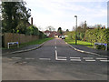
Maddox Drive, Worth, Crawley
Infill development where there were houses with large gardens.
Image: © Robin Webster
Taken: 14 Feb 2007
0.02 miles
2
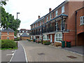
Houses, Stone Court, Crawley
Stone Court was formerly a large house in large grounds. It was demolished, and its grounds, plus the ends of some long back gardens on Church Lane, used to build over 100 dwellings of various types.
Image: © Robin Webster
Taken: 8 Aug 2013
0.04 miles

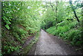
6
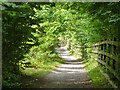
Worth Way, Crawley
A fairly recent creation from Church Lane to Balcombe Road and onto the old railway route westwards. It is along the top of the railway cutting at the right, simplifying the route for horses and cycles. There is a public footpath along the bottom of the cutting, but it offers no access at its eastern end, except on foot, as it starts in a long flight of steps. There is no connection at all down from Church Lane at the bridge.
Image: © Robin Webster
Taken: 8 Aug 2013
0.06 miles
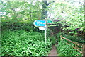
7

Church Road, Worth, after snow
The pavement is on the left, but anything goes today.
Image: © Robin Webster
Taken: 6 Jan 2010
0.07 miles
8
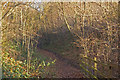
Old railway route
The cutting of the former Three Bridges to East Grinstead railway, opened in 1855 and closed in the 1960s. To the west of here, the trackbed forms part of the Worth Way cycle/footpath, which is part of National Cycle Network route 21. At this point in an eastbound direction, the route leaves the cutting, due to infill further east, including the blocking of the route by the M23 motorway, although it continues as a footpath for a short distance, as seen here.
Image: © Ian Capper
Taken: 27 Dec 2008
0.07 miles
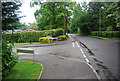
10
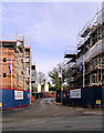
Site Entrance - Stone Court
Urban infilling - Stone Court was a house in large grounds. Now being redeveloped for 120 dwellings.
Image: © Robin Webster
Taken: 14 Feb 2007
0.07 miles