IMAGES TAKEN NEAR TO
Angell Close, CRAWLEY, RH10 7NG
Introduction
This page details the photographs taken nearby to Angell Close, RH10 7NG by members of the Geograph project.
The Geograph project started in 2005 with the aim of publishing, organising and preserving representative images for every square kilometre of Great Britain, Ireland and the Isle of Man.

There are currently over 7.5m images from over14,400 individuals and you can help contribute to the project by visiting https://www.geograph.org.uk
Image Map
Images are licensed for reuse under creativecommons.org/licenses/by-sa/2.0
Notes
- Clicking on the map will re-center to the selected point.
- The higher the marker number, the further away the image location is from the centre of the postcode.
Image Listing (96 Images Found)
Images are licensed for reuse under creativecommons.org/licenses/by-sa/2.0
Image
Details
Distance
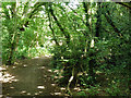
1
Footpath crossing of Billinton Drive
The path continues to the left of the bush, to eventually pass under the railway.
Image: © Robin Webster
Taken: 8 Aug 2013
0.04 miles
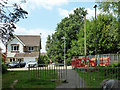
2
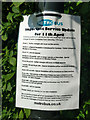
Metrobus coronavirus changes
Note that these are 'further changes' in most cases. The website gives the full picture.
Image: © Robin Webster
Taken: 26 Apr 2020
0.04 miles
3
Path along Gatwick Stream, Maidenbower, Crawley
The stream is to the right, beyond the low flood bank.
Image: © Robin Webster
Taken: 12 Feb 2021
0.05 miles
4

Footpath by old pond bay
The pond bay for Blackwater Green Forge (long gone, as is the pond) is on the right.
Image: © Robin Webster
Taken: 18 Dec 2009
0.05 miles
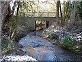
5
Path by Gatwick Stream crosses Haworth Road
Looking upstream with the bridge over the stream to the left.
Image: © Robin Webster
Taken: 12 Feb 2021
0.05 miles
6
Footpath crossing of Haworth Road, Maidenbower, Crawley
The footpath follows the Gatwick Stream. The railings on the right are on the road bridge over the stream. The red barriers are around holes where old sodium lamp posts are being replaced with a more efficient type.
Image: © Robin Webster
Taken: 8 Aug 2013
0.05 miles
7
Footpath by old pond bay
The pond bay for Blackwater Green Forge (long gone, as is the pond) is on the right, but too overgrown to get a meaningful photograph. The footpath runs below it, and after crossing the Gatwick Stream ahead, on top of it.
Image: © Robin Webster
Taken: 8 Aug 2013
0.06 miles
8
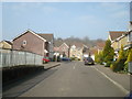
Haworth Road, Maidenbower, Crawley, West Sussex
Image: © Stacey Harris
Taken: 21 Mar 2009
0.06 miles
9
Haworth Road bridges the Gatwick Stream
Looking downstream.
Image: © Robin Webster
Taken: 12 Feb 2021
0.06 miles
10
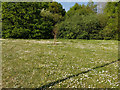
Daisies
On a patch of green by Billinton Drive, Maidenbower, Crawley.
Image: © Robin Webster
Taken: 26 Apr 2020
0.06 miles