IMAGES TAKEN NEAR TO
Tyne Close, CRAWLEY, RH10 7GG
Introduction
This page details the photographs taken nearby to Tyne Close, RH10 7GG by members of the Geograph project.
The Geograph project started in 2005 with the aim of publishing, organising and preserving representative images for every square kilometre of Great Britain, Ireland and the Isle of Man.

There are currently over 7.5m images from over14,400 individuals and you can help contribute to the project by visiting https://www.geograph.org.uk
Image Map
Images are licensed for reuse under creativecommons.org/licenses/by-sa/2.0
Notes
- Clicking on the map will re-center to the selected point.
- The higher the marker number, the further away the image location is from the centre of the postcode.
Image Listing (124 Images Found)
Images are licensed for reuse under creativecommons.org/licenses/by-sa/2.0
Image
Details
Distance
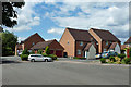
1
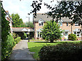
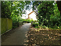
Housing, Clifton Road, Maidenbower, Crawley
The actual road is at the end of the path. The houses are back to front, facing away from the road.
Image: © Robin Webster
Taken: 8 Aug 2013
0.03 miles
2
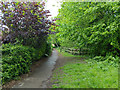
Path following Gatwick Stream, Maidenbower, Crawley
Heading upstream.
Image: © Robin Webster
Taken: 1 May 2020
0.04 miles
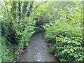
3
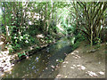
Gatwick Stream, Maidenbower, Crawley
A tributary of the River Mole, which it joins just north of Gatwick Airport.
Image: © Robin Webster
Taken: 8 Aug 2013
0.04 miles
4
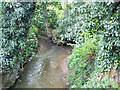
Confluence of Gatwick Stream and Stanford Brook
The major flow is coming from Stanford Brook to the right.
Image: © Robin Webster
Taken: 1 May 2020
0.05 miles
5
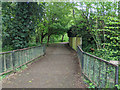
Footpath 102_1W bridges the Gatwick Stream
The stream flows to the left.
Image: © Robin Webster
Taken: 11 Jul 2020
0.05 miles
6
Gatwick Stream, Maidenbower, Crawley
Looking downstream, just after the confluence with the Stanford Brook. Most of the flow is coming from the Stanford Brook.
Image: © Robin Webster
Taken: 1 May 2020
0.06 miles
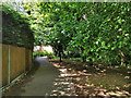
7
Public footpath along Gatwick Stream, Maidenbower, Crawley
The stream is to the left, deeply sunken.
Image: © Robin Webster
Taken: 8 Aug 2013
0.06 miles
8
Footpath 102_1W along Stanford Brook
Heading north, about to bridge the Gatwick Stream, which Stanford Brook joins, although the brook appears to be the major contributor to the combined flow.
Image: © Robin Webster
Taken: 11 Jul 2020
0.06 miles
9
Bridge over Gatwick Stream, Maidenbower, Crawley
Just downstream of the junction with the Stanford Brook, this path follows the brook upstream. Another path follows upstream what is presumably still the Gatwick Stream, although the lesser of the two streams, judging from the flow seen at the confluence at this time.
Image: © Robin Webster
Taken: 1 May 2020
0.06 miles
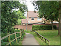
10
Houses, Bancroft Road, Maidenbower, Crawley
This is at the end of the road, with a foot connection to the path along the bank of the Gatwick Stream.
Image: © Robin Webster
Taken: 10 Aug 2013
0.07 miles