IMAGES TAKEN NEAR TO
Moat Walk, CRAWLEY, RH10 7ED
Introduction
This page details the photographs taken nearby to Moat Walk, RH10 7ED by members of the Geograph project.
The Geograph project started in 2005 with the aim of publishing, organising and preserving representative images for every square kilometre of Great Britain, Ireland and the Isle of Man.

There are currently over 7.5m images from over14,400 individuals and you can help contribute to the project by visiting https://www.geograph.org.uk
Image Map (108 Images)


Leaflet Map data © OpenStreetMap
Images are licensed for reuse under creativecommons.org/licenses/by-sa/2.0
Notes
- Clicking on the map will re-center to the selected point.
- The higher the marker number, the further away the image location is from the centre of the postcode.
Image Listing (108 Images Found)
Images are licensed for reuse under creativecommons.org/licenses/by-sa/2.0
Image
Details
Distance
1
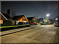
Moat Walk, Pound Hill, Crawley
A residential dead-end, but leading to a footpath through to Worth Park Avenue.
Image: © Robin Webster
Taken: 3 Feb 2021
0.03 miles
2
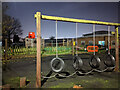
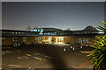
Play apparatus, Pound Hill schools
A night view.
Image: © Robin Webster
Taken: 24 Nov 2020
0.06 miles
3
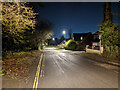
Crawley Lane, Pound Hill, Crawley
Looking towards Three Bridges and the town centre.
Image: © Robin Webster
Taken: 3 Feb 2021
0.06 miles
4
Crawley Lane, Pound Hill, Crawley
Since the New Town came into being, bypassed by Worth Road.
Image: © Robin Webster
Taken: 3 Mar 2023
0.06 miles
5
Pound Hill Infant Academy by night
Rated 'Outstanding' when it was a school, no data available in academy guise.
Image: © Robin Webster
Taken: 24 Nov 2020
0.07 miles
6
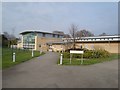
Pound Hill Infant School
Infant, formerly first school on shared campus with Pound Hill Junior.sch
Image: © Michael of Crawley
Taken: 6 Apr 2009
0.07 miles
7
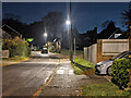
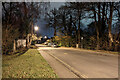
Crawley Lane, Pound Hill, Crawley, by night
Looking towards Three Bridges and the town centre.
Image: © Robin Webster
Taken: 24 Nov 2020
0.07 miles
8
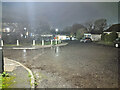
Pound Hill Place, Pound Hill, Crawley
Looking towards the end of this angled dead-end, largely a service road for shops and garages, with no houses.
Image: © Robin Webster
Taken: 3 Feb 2021
0.08 miles
9
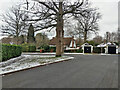
Mount Close, Pound Hill, Crawley
A loop of large well-spaced houses.
Image: © Robin Webster
Taken: 10 Feb 2021
0.09 miles
10
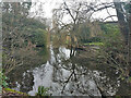
The Moat, Pound Hill, Crawley
A scheduled Ancient Monument, along with the earthwork along which a path gives access from the north. This is the north corner of the square moat. The public can only access (through a fence) most of one side, the rest is in private hands.
Image: © Robin Webster
Taken: 2 Feb 2021
0.09 miles