IMAGES TAKEN NEAR TO
Spring Plat, CRAWLEY, RH10 7DE
Introduction
This page details the photographs taken nearby to Spring Plat, RH10 7DE by members of the Geograph project.
The Geograph project started in 2005 with the aim of publishing, organising and preserving representative images for every square kilometre of Great Britain, Ireland and the Isle of Man.

There are currently over 7.5m images from over14,400 individuals and you can help contribute to the project by visiting https://www.geograph.org.uk
Image Map
Images are licensed for reuse under creativecommons.org/licenses/by-sa/2.0
Notes
- Clicking on the map will re-center to the selected point.
- The higher the marker number, the further away the image location is from the centre of the postcode.
Image Listing (137 Images Found)
Images are licensed for reuse under creativecommons.org/licenses/by-sa/2.0
Image
Details
Distance
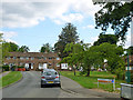
1
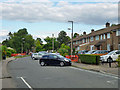
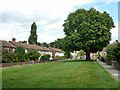
Spring Plat, Pound Hill, Crawley
A fairly long road beginning and ending on the main road, Worth Road. This is the quieter end.
Image: © Robin Webster
Taken: 9 Aug 2013
0.01 miles
2
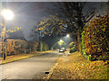
Where a lamp post was
On Spring Plat, Pound Hill, Crawley. Sodium street lighting is being replaced by more efficient lighting in this district.
Image: © Robin Webster
Taken: 10 Aug 2013
0.04 miles
3
Blackwater Lane, Pound Hill, Crawley
Looking west.
Image: © Robin Webster
Taken: 4 Dec 2019
0.05 miles
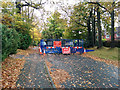
4
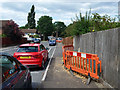
Blackwater Lane, Pound Hill, Crawley
The red barriers are around holes where lamp posts with sodium lights are being replaced with a more efficient lighting. The old posts have been removed, but holes remain and the new posts are yet to be powered up.
Image: © Robin Webster
Taken: 8 Aug 2013
0.05 miles
5
Long Close, Pound Hill, Crawley
The vehicular part of the close is only a car park. The houses face each other across this green.
Image: © Robin Webster
Taken: 10 Aug 2013
0.05 miles
6
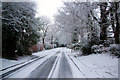
Blackwater Lane in the Snow
Formerly the approach to Blackwater Farm, now a residential street in Crawley.
Image: © Robin Webster
Taken: 24 Jan 2007
0.06 miles
7
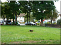
Cat on the prowl
Long Close, Pound Hill, Crawley. The vehicular part of the close is only a car park. The houses face each other across this green.
Image: © Robin Webster
Taken: 10 Aug 2013
0.06 miles
8
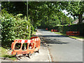
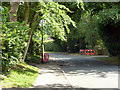
Blackwater Lane, Pound Hill, Crawley
The red barriers are around holes where lamp posts with sodium lights are being replaced with a more efficient lighting. The old posts have been removed, but holes remain and the new posts are yet to be powered up.
Image: © Robin Webster
Taken: 8 Aug 2013
0.06 miles
9
Burleys Road, Pound Hill, Crawley
A road with small bungalows, presumably for elderly people. Spring Plat is ahead.
Image: © Robin Webster
Taken: 9 Aug 2013
0.07 miles
10
Blackwater Lane is closed
A hole has been dug, and left, while they go away and think about what to do next.
Image: © Robin Webster
Taken: 9 Nov 2016
0.07 miles