IMAGES TAKEN NEAR TO
Hawkins Road, CRAWLEY, RH10 5NW
Introduction
This page details the photographs taken nearby to Hawkins Road, RH10 5NW by members of the Geograph project.
The Geograph project started in 2005 with the aim of publishing, organising and preserving representative images for every square kilometre of Great Britain, Ireland and the Isle of Man.

There are currently over 7.5m images from over14,400 individuals and you can help contribute to the project by visiting https://www.geograph.org.uk
Image Map (Loading...)


Getting Data...Please wait
Leaflet Map data © OpenStreetMap
Images are licensed for reuse under creativecommons.org/licenses/by-sa/2.0
Notes
- Clicking on the map will re-center to the selected point.
- The higher the marker number, the further away the image location is from the centre of the postcode.
Image Listing (49 Images Found)
Images are licensed for reuse under creativecommons.org/licenses/by-sa/2.0
Image
Details
Distance
1
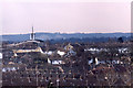
Telephoto view from Tilgate Park in 1987 (2)
The church on the left of the photo is St Mary's Church in Forester Road in the Southgate area of Crawley. To see a normal view from the same vantage point see Image .
Image: © Peter Shimmon
Taken: Unknown
0.08 miles
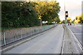
2
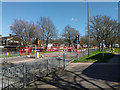
Road block, Hawth Avenue, Crawley
The road was up further along, but access to residential side turnings was allowed for from the other end.
Image: © Robin Webster
Taken: 24 Mar 2019
0.12 miles
3
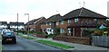
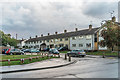
1950s Housing Estate - Rhodes Way in the Tilgate neighbourhood, Crawley, West Sussex
This is one of the older neighbourhoods of Crawley, built as the town was being developed and expanded as a "New Town". These houses were built by Taylor Woodrow in 1957. Contrasting with the housing of the more modern neighbourhood of Maidenbower (see grid square TQ2934), these houses are of a much more uniform appearance from the outside. Fifty years has allowed a few variations of porches to be built on the front, but that's about it! This part of the estate was originally built as a batch of 3 bedroom semi-detached houses (though some have since been extended to the side and the occasional loft conversion provides extra bedrooms).
Image: © Pete Chapman
Taken: 15 Sep 2005
0.13 miles
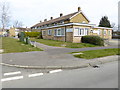
5
Fisher Close
Cul-de-sac off Southgate Drive, part of the 1950s development of the new town of Crawley.
Image: © Ian Capper
Taken: 9 Aug 2018
0.14 miles
7
Southgate Avenue at Tilgate Way junction
Image: © Roger Templeman
Taken: 19 Sep 2015
0.14 miles
9
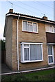
#35 Southgate Drive
There is an Ordnance Survey benchmark Image on the left hand side of the house near the front corner
Image: © Roger Templeman
Taken: 19 Sep 2015
0.15 miles
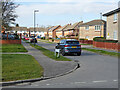
10
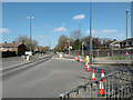
A2004 Southgate Avenue, Crawley
Looking towards the town centre, with a closed Hawth Avenue to the right. Trenching work was going on.
Image: © Robin Webster
Taken: 24 Mar 2019
0.16 miles