IMAGES TAKEN NEAR TO
Salisbury Road, CRAWLEY, RH10 5LX
Introduction
This page details the photographs taken nearby to Salisbury Road, RH10 5LX by members of the Geograph project.
The Geograph project started in 2005 with the aim of publishing, organising and preserving representative images for every square kilometre of Great Britain, Ireland and the Isle of Man.

There are currently over 7.5m images from over14,400 individuals and you can help contribute to the project by visiting https://www.geograph.org.uk
Image Map
Images are licensed for reuse under creativecommons.org/licenses/by-sa/2.0
Notes
- Clicking on the map will re-center to the selected point.
- The higher the marker number, the further away the image location is from the centre of the postcode.
Image Listing (102 Images Found)
Images are licensed for reuse under creativecommons.org/licenses/by-sa/2.0
Image
Details
Distance
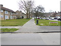
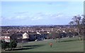
1
Houses on Salisbury Road, Tilgate, Crawley
Image: © Robin Webster
Taken: 12 Feb 2021
0.00 miles
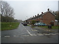
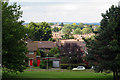
4
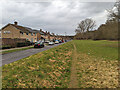
Salisbury Road, Tilgate, Crawley
The houses face the northern edge of Tilgate Park.
Image: © Robin Webster
Taken: 6 Mar 2023
0.03 miles
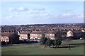
5
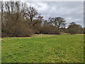
Northern margins of Tilgate Park, Crawley
Image: © Robin Webster
Taken: 6 Mar 2023
0.04 miles
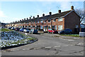
7
Houses in Tilgate, Crawley, West Sussex
Image: © Oast House Archive
Taken: 23 Aug 2008
0.06 miles
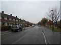
8
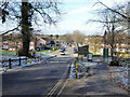
View down Titmus Drive from Tilgate Park entrance, Crawley
Image: © Robin Webster
Taken: 12 Feb 2021
0.06 miles