IMAGES TAKEN NEAR TO
The Furrows, CRAWLEY, RH10 4ZT
Introduction
This page details the photographs taken nearby to The Furrows, RH10 4ZT by members of the Geograph project.
The Geograph project started in 2005 with the aim of publishing, organising and preserving representative images for every square kilometre of Great Britain, Ireland and the Isle of Man.

There are currently over 7.5m images from over14,400 individuals and you can help contribute to the project by visiting https://www.geograph.org.uk
Image Map (Loading...)


Getting Data...Please wait
Leaflet Map data © OpenStreetMap
Images are licensed for reuse under creativecommons.org/licenses/by-sa/2.0
Notes
- Clicking on the map will re-center to the selected point.
- The higher the marker number, the further away the image location is from the centre of the postcode.
Image Listing (74 Images Found)
Images are licensed for reuse under creativecommons.org/licenses/by-sa/2.0
Image
Details
Distance
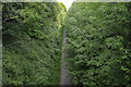
3
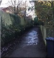
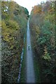
The Worth Way
The Worth Way continues westwards towards Crawley along an enclosed path for a short section.
Image: © Chris Thomas-Atkin
Taken: 28 Dec 2017
0.06 miles
5
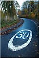
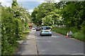
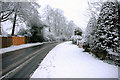
Looking west into Grange Road from Turners Hill Road, Crawley Down
Sadly, the sign is ignored by most. Grange Road, named after The Grange in nearby Sand Hill lane.
Image: © CDSnapper
Taken: 8 Nov 2008
0.09 miles
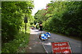
9
The Worth Way, looking towards Crawley Down from the bridge carrying the B2028 Turners Hill Road
Former Railway line closed in the 1960's now used by cycling commuters and dog walkers
Image: © CDSnapper
Taken: 8 Nov 2008
0.12 miles
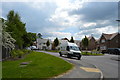
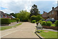
10
Grange Road, Crawley Down
Looking west from junction of Grange Road with Grange Crescent
Image: © CDSnapper
Taken: 8 Feb 2007
0.12 miles