IMAGES TAKEN NEAR TO
Burleigh Close, CRAWLEY, RH10 4UX
Introduction
This page details the photographs taken nearby to Burleigh Close, RH10 4UX by members of the Geograph project.
The Geograph project started in 2005 with the aim of publishing, organising and preserving representative images for every square kilometre of Great Britain, Ireland and the Isle of Man.

There are currently over 7.5m images from over14,400 individuals and you can help contribute to the project by visiting https://www.geograph.org.uk
Image Map
Images are licensed for reuse under creativecommons.org/licenses/by-sa/2.0
Notes
- Clicking on the map will re-center to the selected point.
- The higher the marker number, the further away the image location is from the centre of the postcode.
Image Listing (35 Images Found)
Images are licensed for reuse under creativecommons.org/licenses/by-sa/2.0
Image
Details
Distance
1
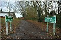
Footpath to Rowan Walk, Crawley Down
Just in case you weren't sure, this is the footpath to Rowan Walk, Crawley Down - in keeping with the Geograph rules, no digital enhancement used!
Image: © CDSnapper
Taken: 23 Nov 2008
0.07 miles
2

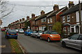
Bowers Place, Crawley Down
The first major development in Crawley Down after the railway arrived in 1860. The long terrace was built in the 1890s to house workers from the new brickfields operating to the south and east.
Image: © Simon Carey
Taken: 5 May 2024
0.18 miles
4
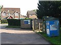
Haven Sports Field car park
Recycling facilities in the Haven Sports Field car park.
Image: © Nikki Mahadevan
Taken: 25 Aug 2006
0.20 miles
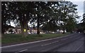
5
Village green, Crawley Down
Looking from Station Road towards Bowers Place.
Image: © Robin Webster
Taken: 20 May 2023
0.20 miles
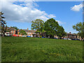
6

Village Green, Crawley Down
A trangular piece of land bounded to the east by Bowers Place and west by Station Road meeting at the foot of the hill where there is a small playground.
Image: © Simon Carey
Taken: 5 May 2024
0.20 miles
7
Bowers Place, Crawley Down
Looking north into Bowers Place from the shops
Image: © CDSnapper
Taken: 9 Nov 2008
0.20 miles
8
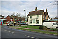
The Royal Oak, Crawley Down, 2009
Later closed.
Image: © Robin Webster
Taken: 11 Mar 2009
0.20 miles
9
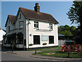
The Royal Oak, Crawley Down
The pub stands on the corner of Station Road (foreground) and Burleigh Way.
Image: © Stephen Craven
Taken: 25 Apr 2011
0.20 miles
10

Health Centre, Bowers Place, Crawley Down
Opened in 1982 to cater for the rapidly expanding village.
Image: © Simon Carey
Taken: 5 May 2024
0.20 miles