IMAGES TAKEN NEAR TO
Paddockhurst Road, CRAWLEY, RH10 4SF
Introduction
This page details the photographs taken nearby to Paddockhurst Road, RH10 4SF by members of the Geograph project.
The Geograph project started in 2005 with the aim of publishing, organising and preserving representative images for every square kilometre of Great Britain, Ireland and the Isle of Man.

There are currently over 7.5m images from over14,400 individuals and you can help contribute to the project by visiting https://www.geograph.org.uk
Image Map
Images are licensed for reuse under creativecommons.org/licenses/by-sa/2.0
Notes
- Clicking on the map will re-center to the selected point.
- The higher the marker number, the further away the image location is from the centre of the postcode.
Image Listing (8 Images Found)
Images are licensed for reuse under creativecommons.org/licenses/by-sa/2.0
Image
Details
Distance
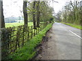
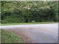
1
The junction of Paddockhurst Road and Back Lane
Image: © Shazz
Taken: 2 Apr 2017
0.11 miles
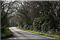
2
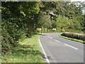
Sharp bend on the B2110
West of Turners Hill.
Image: © Dave Spicer
Taken: 15 Oct 2012
0.12 miles
3
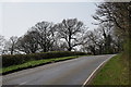
Round the Bend
Paddockhurst Road (B2110), west of Turners Hill.
Image: © Peter Trimming
Taken: 29 Mar 2019
0.12 miles
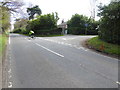
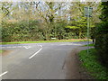
4
Back Lane junction with Paddockhurst Road
Image: © Dave Spicer
Taken: 15 Oct 2012
0.12 miles
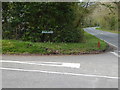
6
Road Junction
The junction of Back Lane with Paddockhurst Road (B2110).
Image: © Peter Trimming
Taken: 29 Mar 2019
0.13 miles
7
Looking southwards on Paddockhurst road from the junction with Back Lane
Image: © Shazz
Taken: 2 Apr 2017
0.18 miles