IMAGES TAKEN NEAR TO
Withypitts, CRAWLEY, RH10 4PJ
Introduction
This page details the photographs taken nearby to Withypitts, RH10 4PJ by members of the Geograph project.
The Geograph project started in 2005 with the aim of publishing, organising and preserving representative images for every square kilometre of Great Britain, Ireland and the Isle of Man.

There are currently over 7.5m images from over14,400 individuals and you can help contribute to the project by visiting https://www.geograph.org.uk
Image Map
Images are licensed for reuse under creativecommons.org/licenses/by-sa/2.0
Notes
- Clicking on the map will re-center to the selected point.
- The higher the marker number, the further away the image location is from the centre of the postcode.
Image Listing (53 Images Found)
Images are licensed for reuse under creativecommons.org/licenses/by-sa/2.0
Image
Details
Distance
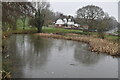
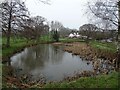
5
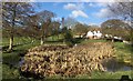
Pond at Turners Hill
A pond beside the Selsfield Road at Turners Hill.
Image: © Chris Thomas-Atkin
Taken: 7 Jan 2018
0.09 miles

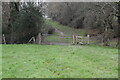
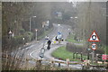
9
Speed Sign
A Speed Indicator on the outskirts of Turners Hill. An approaching vehicle on the road, not in shot, had triggered the warning to slow down.
Image: © Chris Thomas-Atkin
Taken: 7 Jan 2018
0.11 miles
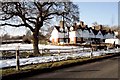
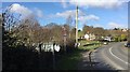
10
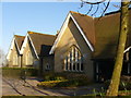
Turners Hill Primary School
Late Victorian school building beside the crossroads at the hilltop on Turners Hill.
Image: © Colin Smith
Taken: 5 Apr 2010
0.13 miles