IMAGES TAKEN NEAR TO
Wallage Lane, CRAWLEY, RH10 4NG
Introduction
This page details the photographs taken nearby to Wallage Lane, RH10 4NG by members of the Geograph project.
The Geograph project started in 2005 with the aim of publishing, organising and preserving representative images for every square kilometre of Great Britain, Ireland and the Isle of Man.

There are currently over 7.5m images from over14,400 individuals and you can help contribute to the project by visiting https://www.geograph.org.uk
Image Map
Images are licensed for reuse under creativecommons.org/licenses/by-sa/2.0
Notes
- Clicking on the map will re-center to the selected point.
- The higher the marker number, the further away the image location is from the centre of the postcode.
Image Listing (102 Images Found)
Images are licensed for reuse under creativecommons.org/licenses/by-sa/2.0
Image
Details
Distance
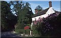
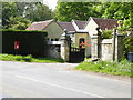
3
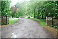
Near Rowfant House
On the road just to the east of Rowfant House
Image: © CDSnapper
Taken: 9 Nov 2008
0.03 miles
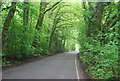
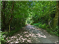
6
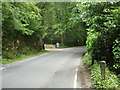
Wallage Lane at Rowfant House entrance
The current vehicle entrance bypasses the lodge on Wallage Lane, some way behind the camera, but the public footpath through Rowfant House still uses the old route. Pedestrians have to walk some distance one way or the other along the lane to access the Worth Way off-road route. This direction is mapped as a section of the Sussex Border Path. As may be seen the lane is not pedestrian-friendly, and has a fair amount of traffic. It is crying out for a permissive footpath to be made just inside the Rowfant House grounds on the left.
Image: © Robin Webster
Taken: 11 Jun 2014
0.03 miles
7
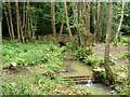
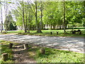
Stream in Rowfant House grounds
This curves round to feed into the fishponds to the north of the house. Public footpath 31W crosses the bridge, a former route of the main drive to the house.
Image: © Robin Webster
Taken: 11 Jun 2014
0.05 miles
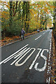
10
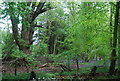
Worth Way, Rowfant
Here the path deviates from the old railway line to run closely parallel but behind the old station area which was to the right. The station area became a Colas depot when the railway closed. Colas have recently vacated this and the site sold.
Image: © Robin Webster
Taken: 9 Jul 2022
0.08 miles