IMAGES TAKEN NEAR TO
Turners Hill Road, CRAWLEY, RH10 4NB
Introduction
This page details the photographs taken nearby to Turners Hill Road, RH10 4NB by members of the Geograph project.
The Geograph project started in 2005 with the aim of publishing, organising and preserving representative images for every square kilometre of Great Britain, Ireland and the Isle of Man.

There are currently over 7.5m images from over14,400 individuals and you can help contribute to the project by visiting https://www.geograph.org.uk
Image Map (Loading...)


Getting Data...Please wait
Leaflet Map data © OpenStreetMap
Images are licensed for reuse under creativecommons.org/licenses/by-sa/2.0
Notes
- Clicking on the map will re-center to the selected point.
- The higher the marker number, the further away the image location is from the centre of the postcode.
Image Listing (44 Images Found)
Images are licensed for reuse under creativecommons.org/licenses/by-sa/2.0
Image
Details
Distance
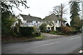
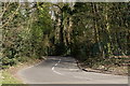
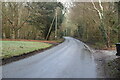
2
Turners Hill Road
Seen at the junction with Wallage Lane.
Image: © Peter Trimming
Taken: 29 Mar 2019
0.01 miles
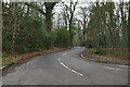
3
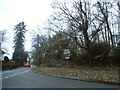
Wallage Lane at the junction of Turners Hill Road
Image: © David Howard
Taken: 6 Feb 2017
0.02 miles
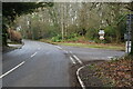
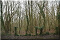
5
Wallage Lane
Seen from the junction with Turners Hill Road.
Image: © Peter Trimming
Taken: 29 Mar 2019
0.02 miles
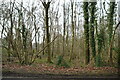
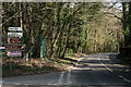
10

Worth Way towards Rowfant
Using the route of the old Three Bridges - East Grinstead railway.
Image: © Robin Webster
Taken: 9 Jul 2022
0.11 miles