IMAGES TAKEN NEAR TO
Station Road, CRAWLEY, RH10 4HZ
Introduction
This page details the photographs taken nearby to Station Road, RH10 4HZ by members of the Geograph project.
The Geograph project started in 2005 with the aim of publishing, organising and preserving representative images for every square kilometre of Great Britain, Ireland and the Isle of Man.

There are currently over 7.5m images from over14,400 individuals and you can help contribute to the project by visiting https://www.geograph.org.uk
Image Map
Images are licensed for reuse under creativecommons.org/licenses/by-sa/2.0
Notes
- Clicking on the map will re-center to the selected point.
- The higher the marker number, the further away the image location is from the centre of the postcode.
Image Listing (50 Images Found)
Images are licensed for reuse under creativecommons.org/licenses/by-sa/2.0
Image
Details
Distance
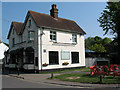
1
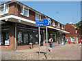
Shops on Station Road
This parade of shops on Station Road, Crawley Down included (as of 2011) an estate agent, fast food outlet, and a newsagent (with sub post office).
In the foreground is a sign for the Worth Way (part of NCN 21).
Image: © Stephen Craven
Taken: 25 Apr 2011
0.01 miles
2
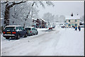
Crawley Down Village Centre
The shops at Crawley Down during 'The Big Freeze' January 2010
Image: © CDSnapper
Taken: 6 Jan 2008
0.01 miles
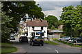
3
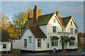
The Royal Oak Public House, Crawley Down
Situated in the heart of the village opposite the shops at the junction of Burleigh Way and Station Road. Does a great pint of Harveys!
Image: © CDSnapper
Taken: 2 Nov 2008
0.01 miles
4
The Royal Oak, Crawley Down, 2009
Later closed.
Image: © Robin Webster
Taken: 11 Mar 2009
0.01 miles
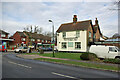
5
The Royal Oak, Crawley Down
The pub stands on the corner of Station Road (foreground) and Burleigh Way.
Image: © Stephen Craven
Taken: 25 Apr 2011
0.01 miles
7
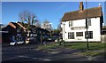
Crawley Down
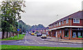
The centre of the village with the Royal Oak public house on the right.
Image: © Chris Thomas-Atkin
Taken: 28 Dec 2017
0.02 miles
8
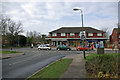
Shops, Crawley Down
Built on the site of Grange Road station on the Three Bridges - East Grinstead line.
Image: © Robin Webster
Taken: 11 Mar 2009
0.02 miles
9
Site of Grange Road station, 1992
View westward on Station Road in Crawley Down, towards Three Bridges: ex-LB&SCR Three Bridges - East Grinstead lin. The station and line were closed entirely from 2/1/67.
Image: © Ben Brooksbank
Taken: 11 Oct 1992
0.03 miles
10

Village Green, Crawley Down
A trangular piece of land bounded to the east by Bowers Place and west by Station Road meeting at the foot of the hill where there is a small playground.
Image: © Simon Carey
Taken: 5 May 2024
0.06 miles