IMAGES TAKEN NEAR TO
Sandy Close, CRAWLEY, RH10 4HW
Introduction
This page details the photographs taken nearby to Sandy Close, RH10 4HW by members of the Geograph project.
The Geograph project started in 2005 with the aim of publishing, organising and preserving representative images for every square kilometre of Great Britain, Ireland and the Isle of Man.

There are currently over 7.5m images from over14,400 individuals and you can help contribute to the project by visiting https://www.geograph.org.uk
Image Map
Images are licensed for reuse under creativecommons.org/licenses/by-sa/2.0
Notes
- Clicking on the map will re-center to the selected point.
- The higher the marker number, the further away the image location is from the centre of the postcode.
Image Listing (79 Images Found)
Images are licensed for reuse under creativecommons.org/licenses/by-sa/2.0
Image
Details
Distance
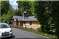
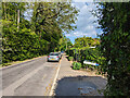
3

Lodge on Sandy Lane
See also http://www.geograph.org.uk/photo/5124719 from May of the same year.
Image: © Shazz
Taken: 9 Oct 2016
0.05 miles
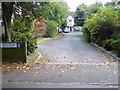
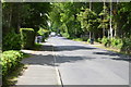
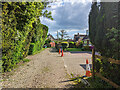
5
Sandy Lane, Crawley Down
Looking east.
Image: © Robin Webster
Taken: 20 May 2023
0.05 miles
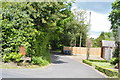
7
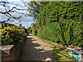
Gardner Lane, Crawley Down
A private road but public footpath Worth 101W, through from Squires Close.
Image: © Robin Webster
Taken: 20 May 2023
0.07 miles
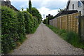
9
Gardner Lane, Crawley Down
A private road but public footpath Worth 101W, through to Squires Close.
Image: © Robin Webster
Taken: 20 May 2023
0.08 miles