IMAGES TAKEN NEAR TO
Sandy Lane, CRAWLEY, RH10 4HU
Introduction
This page details the photographs taken nearby to Sandy Lane, RH10 4HU by members of the Geograph project.
The Geograph project started in 2005 with the aim of publishing, organising and preserving representative images for every square kilometre of Great Britain, Ireland and the Isle of Man.

There are currently over 7.5m images from over14,400 individuals and you can help contribute to the project by visiting https://www.geograph.org.uk
Image Map
Images are licensed for reuse under creativecommons.org/licenses/by-sa/2.0
Notes
- Clicking on the map will re-center to the selected point.
- The higher the marker number, the further away the image location is from the centre of the postcode.
Image Listing (46 Images Found)
Images are licensed for reuse under creativecommons.org/licenses/by-sa/2.0
Image
Details
Distance
2
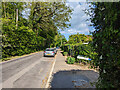
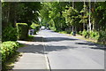
Sandy Lane, Crawley Down
Looking east.
Image: © Robin Webster
Taken: 20 May 2023
0.09 miles
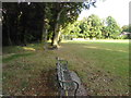
3
Cuttinglye Lane
At the end of the residential part.
Image: © Robin Webster
Taken: 11 Jan 2010
0.09 miles
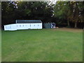
7
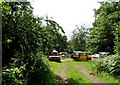
Assortiment of odd cars, Crawley Down
One of the cars seems to be a 'Scamp'.
Image: © nick macneill
Taken: 8 Jul 2011
0.10 miles
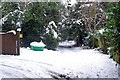
8

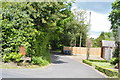
Cuttinglye Lane with blue gates
Beyond the gates the lane is a public footpath with no vehicular access.
Image: © Shazz
Taken: 9 Oct 2016
0.10 miles
10
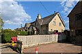
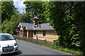
A pair of cottages, Sandy Lane, Crawley Down
A grade II listed building whose detailing is similar to another house along the road which is considered as early 19th century.
Image: © Robin Webster
Taken: 20 May 2023
0.10 miles