IMAGES TAKEN NEAR TO
Turners Hill Road, CRAWLEY, RH10 4HE
Introduction
This page details the photographs taken nearby to Turners Hill Road, RH10 4HE by members of the Geograph project.
The Geograph project started in 2005 with the aim of publishing, organising and preserving representative images for every square kilometre of Great Britain, Ireland and the Isle of Man.

There are currently over 7.5m images from over14,400 individuals and you can help contribute to the project by visiting https://www.geograph.org.uk
Image Map
Images are licensed for reuse under creativecommons.org/licenses/by-sa/2.0
Notes
- Clicking on the map will re-center to the selected point.
- The higher the marker number, the further away the image location is from the centre of the postcode.
Image Listing (66 Images Found)
Images are licensed for reuse under creativecommons.org/licenses/by-sa/2.0
Image
Details
Distance
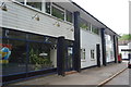
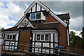
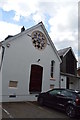
1
Crawley Down Village Hall
Housing Hopscotch Childcare according to the sign.
Image: © Robin Webster
Taken: 13 Jul 2022
0.02 miles
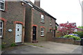
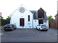
3
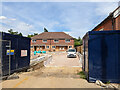
Building site, Crawley Down
Formerly a garage.
Image: © Robin Webster
Taken: 13 Jul 2022
0.03 miles
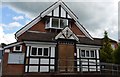
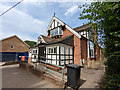
7
Converted building on Sandy Lane
See also http://www.geograph.org.uk/photo/5124745 taken earlier in the same year.
Image: © Shazz
Taken: 9 Oct 2016
0.05 miles