IMAGES TAKEN NEAR TO
Tiltwood Drive, CRAWLEY, RH10 4DP
Introduction
This page details the photographs taken nearby to Tiltwood Drive, RH10 4DP by members of the Geograph project.
The Geograph project started in 2005 with the aim of publishing, organising and preserving representative images for every square kilometre of Great Britain, Ireland and the Isle of Man.

There are currently over 7.5m images from over14,400 individuals and you can help contribute to the project by visiting https://www.geograph.org.uk
Image Map (Loading...)


Getting Data...Please wait
Leaflet Map data © OpenStreetMap
Images are licensed for reuse under creativecommons.org/licenses/by-sa/2.0
Notes
- Clicking on the map will re-center to the selected point.
- The higher the marker number, the further away the image location is from the centre of the postcode.
Image Listing (25 Images Found)
Images are licensed for reuse under creativecommons.org/licenses/by-sa/2.0
Image
Details
Distance
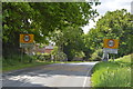
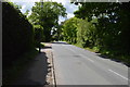
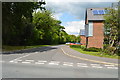
4
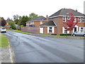
Tiltwood drive looking east
On the right is a short spur to the Drive.
Image: © Shazz
Taken: 9 Oct 2016
0.05 miles
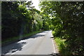
5
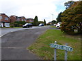
Tiltwood Drive seen from the junction with Aviary Way
Image: © Shazz
Taken: 9 Oct 2016
0.06 miles
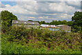
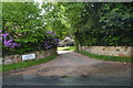
9
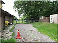
Entrance to Haven Sports Ground, home of Crawley Down FC
The team were preparing for their first season in the Ryman League South.
Image: © nick macneill
Taken: 8 Jul 2011
0.13 miles