IMAGES TAKEN NEAR TO
RH10 3WG
Introduction
This page details the photographs taken nearby to RH10 3WG by members of the Geograph project.
The Geograph project started in 2005 with the aim of publishing, organising and preserving representative images for every square kilometre of Great Britain, Ireland and the Isle of Man.

There are currently over 7.5m images from over14,400 individuals and you can help contribute to the project by visiting https://www.geograph.org.uk
Image Map
Images are licensed for reuse under creativecommons.org/licenses/by-sa/2.0
Notes
- Clicking on the map will re-center to the selected point.
- The higher the marker number, the further away the image location is from the centre of the postcode.
Image Listing (73 Images Found)
Images are licensed for reuse under creativecommons.org/licenses/by-sa/2.0
Image
Details
Distance
1

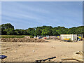
Waste land north of Steers Lane
This has planning permission for 185 dwellings, but no start has been made yet.
Image: © Robin Webster
Taken: 21 Feb 2021
0.03 miles
2

Waste land north of Steers Lane
This has planning permission for 185 dwellings, but no start has been made yet.
Image: © Robin Webster
Taken: 21 Feb 2021
0.05 miles
3
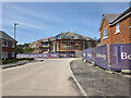
Building site, Forge Wood, Crawley
The latest expansion of the Forge Wood neighbourhood, north of Steers Lane. It seems to be called Riverbrook Place.
Image: © Robin Webster
Taken: 29 May 2023
0.07 miles
4
Building site, Forge Wood, Crawley
The latest expansion of the Forge Wood neighbourhood, north of Steers Lane. It seems to be called Riverbrook Place.
Image: © Robin Webster
Taken: 29 May 2023
0.08 miles
5

Waste land north of Steers Lane
This has planning permission for 185 dwellings, but no start has been made yet.
Image: © Robin Webster
Taken: 21 Feb 2021
0.09 miles
9

Waste land north of Steers Lane
This has planning permission for 185 dwellings, but no start has been made yet.
Image: © Robin Webster
Taken: 21 Feb 2021
0.10 miles
10

Footpath 3377 towards Balcombe Road
This part is a short link from Steers Lane. The waste land traversed has planning permission for 185 dwellings, but no start has been made yet.
Image: © Robin Webster
Taken: 21 Feb 2021
0.10 miles