IMAGES TAKEN NEAR TO
Copthorne Road, CRAWLEY, RH10 3PB
Introduction
This page details the photographs taken nearby to Copthorne Road, RH10 3PB by members of the Geograph project.
The Geograph project started in 2005 with the aim of publishing, organising and preserving representative images for every square kilometre of Great Britain, Ireland and the Isle of Man.

There are currently over 7.5m images from over14,400 individuals and you can help contribute to the project by visiting https://www.geograph.org.uk
Image Map
Images are licensed for reuse under creativecommons.org/licenses/by-sa/2.0
Notes
- Clicking on the map will re-center to the selected point.
- The higher the marker number, the further away the image location is from the centre of the postcode.
Image Listing (8 Images Found)
Images are licensed for reuse under creativecommons.org/licenses/by-sa/2.0
Image
Details
Distance
1
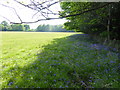
Large field west of Old Hollow with bluebells
Image: © Shazz
Taken: 12 May 2016
0.19 miles
2
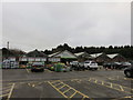
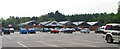
Crawley Garden Centre, Copthorne
This started life over 30 years ago. Originally known as 'Wakehams Green Nurseries, the site became part of Wyevale Garden Centres family in 1996
Image: © Richard Rogerson
Taken: 20 Nov 2016
0.20 miles
3
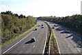
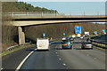
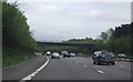
M23
The M23 is about 10% of TQ3037. To the right is Burleys Wood, to the left Crabbet Park. Taken from TQ302378 looking south.
Image: © SGBailey
Taken: 4 Nov 2005
0.21 miles
4
Wyevale Garden Centre, Pound Hill
On the A2220 Copthorne Road.
Image: © Andy Potter
Taken: 12 Sep 2006
0.22 miles
5
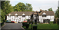
Regency Hotel, Copthorne
Not as old as it looks. We stayed here: nice people; clean; good food.
Image: © Andy Potter
Taken: 9 Sep 2006
0.23 miles
6
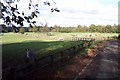
Crabbet Park
35% of TQ3037 is Crabbet Park. Much is used for horses. There is also a fishing lake (not shown). Taken from TQ304375 looking NE.
Image: © SGBailey
Taken: 4 Nov 2005
0.24 miles