IMAGES TAKEN NEAR TO
Forge Wood, CRAWLEY, RH10 3NH
Introduction
This page details the photographs taken nearby to Forge Wood, RH10 3NH by members of the Geograph project.
The Geograph project started in 2005 with the aim of publishing, organising and preserving representative images for every square kilometre of Great Britain, Ireland and the Isle of Man.

There are currently over 7.5m images from over14,400 individuals and you can help contribute to the project by visiting https://www.geograph.org.uk
Image Map
Images are licensed for reuse under creativecommons.org/licenses/by-sa/2.0
Notes
- Clicking on the map will re-center to the selected point.
- The higher the marker number, the further away the image location is from the centre of the postcode.
Image Listing (105 Images Found)
Images are licensed for reuse under creativecommons.org/licenses/by-sa/2.0
Image
Details
Distance
1
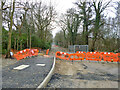
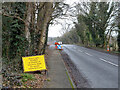
Steers Lane is closed, 2015
Steers Lane was closed for improvements to do with the development of the new Forge Wood Crawley neighbourhood. Traffic was diverted via Radford Road.
Image: © Robin Webster
Taken: 1 Jan 2015
0.03 miles
2
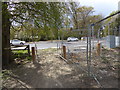
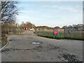
Footpath from the east arrives at a mess on Balcombe Road
Image: © Shazz
Taken: 30 Apr 2016
0.04 miles
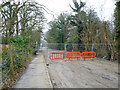
3
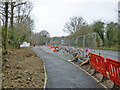
Road works, Balcombe Road, 2015
Steers Lane was closed for improvements to do with the development of the new Forge Wood Crawley neighbourhood. Here the Steers Lane - Balcombe Road junction is being improved.
Image: © Robin Webster
Taken: 1 Jan 2015
0.04 miles
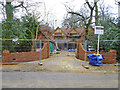
4
Building site north of Steers Lane
'Riverbrook Place' has started. A rather large number of houses.
Image: © Robin Webster
Taken: 28 Nov 2021
0.04 miles
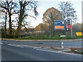
5
Road works, Balcombe Road, 2015
Steers Lane was closed for improvements to do with the development of the new Forge Wood Crawley neighbourhood. The diversion would be via Radford Road.
Image: © Robin Webster
Taken: 1 Jan 2015
0.06 miles
6
New house on Steers Lane, 2015
Built on part of the large plot of an adjacent house, this work was going on at the same time as the first stages of the nearby Forge Wood development, but did not seem to be part of it.
Image: © Robin Webster
Taken: 1 Jan 2015
0.06 miles
7
Steers Lane is closed, 2015
Steers Lane was closed for improvements to do with the development of the new Forge Wood Crawley neighbourhood. Traffic was diverted via Radford Road.
Image: © Robin Webster
Taken: 1 Jan 2015
0.07 miles
8
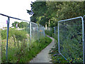
Footpath from Balcombe Road to Copthorne
Fenced to either side as it passes through the building site which is the latest phase of the Forge Wood development. The path is now signposted also as a cycle way to Forge Wood East. This is premature as Forge Wood East is still just this building site.
Image: © Robin Webster
Taken: 28 Aug 2017
0.07 miles
9

Footpath 3377 reaches Steers Lane
A short link from Balcombe Road. The waste land traversed has planning permission for 185 dwellings, but no start has been made yet.
Image: © Robin Webster
Taken: 21 Feb 2021
0.07 miles
10
Exit to Balcombe Road from building site
From those parts of the Forge Wood development east of Balcombe Road.
Image: © Robin Webster
Taken: 21 Feb 2021
0.08 miles