IMAGES TAKEN NEAR TO
Copthorne Common, CRAWLEY, RH10 3LA
Introduction
This page details the photographs taken nearby to Copthorne Common, RH10 3LA by members of the Geograph project.
The Geograph project started in 2005 with the aim of publishing, organising and preserving representative images for every square kilometre of Great Britain, Ireland and the Isle of Man.

There are currently over 7.5m images from over14,400 individuals and you can help contribute to the project by visiting https://www.geograph.org.uk
Image Map (Loading...)


Getting Data...Please wait
Leaflet Map data © OpenStreetMap
Images are licensed for reuse under creativecommons.org/licenses/by-sa/2.0
Notes
- Clicking on the map will re-center to the selected point.
- The higher the marker number, the further away the image location is from the centre of the postcode.
Image Listing (57 Images Found)
Images are licensed for reuse under creativecommons.org/licenses/by-sa/2.0
Image
Details
Distance
1

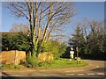
Copthorne village sign
This sign at the eastern end of the village of Copthorne (TQ326393) is metallic engraving with a Millennium theme.
Image: © SGBailey
Taken: 7 Nov 2005
0.06 miles
2
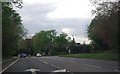
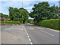
The eastern end of Copthorne
The village of Copthorne extends into this square. This eastern end is viewed looking west from near the A264 junction at TQ326393.
Image: © SGBailey
Taken: 7 Nov 2005
0.06 miles
3
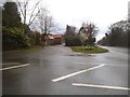
Borers Arms Road
The junction shown from a different angle in Image, with Borers Arms Road leaving Copthorne Common Road (the A264).
Image: © Derek Harper
Taken: 16 Mar 2014
0.07 miles
4
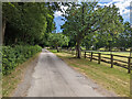
Drive to Courthouse Farm, Copthorne
This is mapped as registered common land up as far as the bend, along with the very narrow belt of woodland on the left and another drive on the other side. The common land then continues as just the narrow woodland. Although evidently not often used as a through route, it was possible to make a transit. This involved climbing a gate into the woodland at the far bend.
Image: © Robin Webster
Taken: 13 Jul 2022
0.07 miles
5
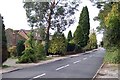
Borers Arms Road, Copthorne
At the junction with Lashmere.
Image: © Robin Webster
Taken: 13 Jul 2022
0.08 miles
6
Borers Arms Road, Copthorne
This was during a heavy hailstorm with lightning
Image: © David Howard
Taken: 3 Apr 2016
0.08 miles
7
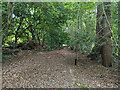
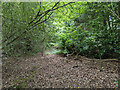
In a narrow finger of Copthorne Common
Although there is no public footpath, it is possible to use this curious strip of public access common land as a through route.
Image: © Robin Webster
Taken: 13 Jul 2022
0.08 miles
8
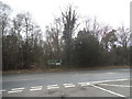
Copthorne Common Road at the junction of Borers Arms Road
Image: © David Howard
Taken: 3 Apr 2016
0.09 miles
9
In a narrow finger of Copthorne Common
Although there is no public footpath, it is possible to use this curious strip of public access common land as a through route. This is the most awkward part.
Image: © Robin Webster
Taken: 13 Jul 2022
0.09 miles