IMAGES TAKEN NEAR TO
St. Annes Road, CRAWLEY, RH10 3HJ
Introduction
This page details the photographs taken nearby to St. Annes Road, RH10 3HJ by members of the Geograph project.
The Geograph project started in 2005 with the aim of publishing, organising and preserving representative images for every square kilometre of Great Britain, Ireland and the Isle of Man.

There are currently over 7.5m images from over14,400 individuals and you can help contribute to the project by visiting https://www.geograph.org.uk
Image Map
Images are licensed for reuse under creativecommons.org/licenses/by-sa/2.0
Notes
- Clicking on the map will re-center to the selected point.
- The higher the marker number, the further away the image location is from the centre of the postcode.
Image Listing (65 Images Found)
Images are licensed for reuse under creativecommons.org/licenses/by-sa/2.0
Image
Details
Distance
2
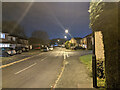
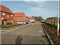
Siena Drive, Pound Hill, Crawley
Mostly houses, but one block of flats, Capua Court, seen ahead.
Image: © Robin Webster
Taken: 24 Nov 2020
0.08 miles
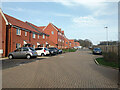
7
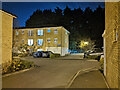
Crommock Street, Forge Wood, Crawley
In the yet growing new Crawley neighbourhood.
Image: © Robin Webster
Taken: 21 Feb 2021
0.12 miles
8

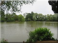
Path from Grattons Park to Clare Close and Grattons Drive
Image: © Robin Webster
Taken: 24 Nov 2020
0.13 miles
9
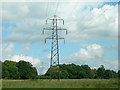
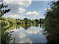
Pylons near Pound Hill
Looking towards Forge Wood.
Image: © Colin Bews
Taken: 16 Jun 2011
0.13 miles
10
Crommock Street, Forge Wood, Crawley
In the yet growing new Crawley neighbourhood.
Image: © Robin Webster
Taken: 21 Feb 2021
0.13 miles