IMAGES TAKEN NEAR TO
Spinel Street, CRAWLEY, RH10 3GA
Introduction
This page details the photographs taken nearby to Spinel Street, RH10 3GA by members of the Geograph project.
The Geograph project started in 2005 with the aim of publishing, organising and preserving representative images for every square kilometre of Great Britain, Ireland and the Isle of Man.

There are currently over 7.5m images from over14,400 individuals and you can help contribute to the project by visiting https://www.geograph.org.uk
Image Map
Images are licensed for reuse under creativecommons.org/licenses/by-sa/2.0
Notes
- Clicking on the map will re-center to the selected point.
- The higher the marker number, the further away the image location is from the centre of the postcode.
Image Listing (95 Images Found)
Images are licensed for reuse under creativecommons.org/licenses/by-sa/2.0
Image
Details
Distance
1
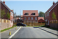
Emerald Road, Forge Wood, Crawley
Forge Wood is a new Crawley neighbourhood, still with much building to come. This seems to be a temporary dead-end.
Image: © Robin Webster
Taken: 26 Aug 2019
0.03 miles
2
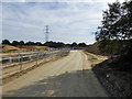
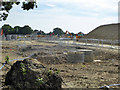
Building site, Forge Wood East
A construction road, possibly also a future road for the housing estate.
Image: © Robin Webster
Taken: 28 Aug 2017
0.05 miles
3
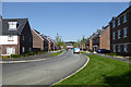
Foxglove Drive, Forge Wood, Crawley
Forge Wood is a new Crawley neighbourhood, still with much building to come. This is the main access road to the finished part of the development to the east of Balcombe Road.
Image: © Robin Webster
Taken: 26 Aug 2019
0.05 miles
4
Building site, Forge Wood 3B
Forge Wood is a new Crawley neighbourhood, still with much building to come.
Image: © Robin Webster
Taken: 26 Aug 2019
0.06 miles
5
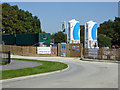
Building site, Forge Wood East
Only groundworks so far in this corner.
Image: © Robin Webster
Taken: 28 Aug 2017
0.07 miles
6
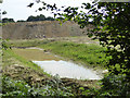
Pond or ditch on Forge Wood East building site
This is a new creation.
Image: © Robin Webster
Taken: 28 Aug 2017
0.07 miles

8
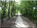
Footpath from Copthorne to Balcombe Road
Looking down the ramp on the west side of the M23 bridge.
Image: © Robin Webster
Taken: 28 Aug 2017
0.09 miles
9
Foxglove Drive, Forge Wood, Crawley
Forge Wood is a new Crawley neighbourhood, still with much building to come. This is the main access road to the finished part of the development to the east of Balcombe Road.
Image: © Robin Webster
Taken: 26 Aug 2019
0.09 miles
10

Footpath from Balcombe Road to Copthorne
The rise some way ahead is up to a bridge over the M23.
Image: © Robin Webster
Taken: 18 Dec 2009
0.09 miles