IMAGES TAKEN NEAR TO
Farmleigh Close, CRAWLEY, RH10 3AH
Introduction
This page details the photographs taken nearby to Farmleigh Close, RH10 3AH by members of the Geograph project.
The Geograph project started in 2005 with the aim of publishing, organising and preserving representative images for every square kilometre of Great Britain, Ireland and the Isle of Man.

There are currently over 7.5m images from over14,400 individuals and you can help contribute to the project by visiting https://www.geograph.org.uk
Image Map
Images are licensed for reuse under creativecommons.org/licenses/by-sa/2.0
Notes
- Clicking on the map will re-center to the selected point.
- The higher the marker number, the further away the image location is from the centre of the postcode.
Image Listing (64 Images Found)
Images are licensed for reuse under creativecommons.org/licenses/by-sa/2.0
Image
Details
Distance
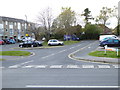
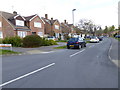
2
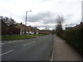
Farmleigh Close, Pound Hill, Crawley
Off Grattons Drive.
Image: © Robin Webster
Taken: 24 Nov 2020
0.03 miles
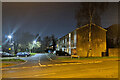
3
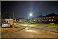
Grattons Drive, Pound Hill, Crawley
Looking from the junction with Leighlands.
Image: © Robin Webster
Taken: 24 Nov 2020
0.05 miles
4
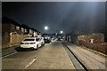
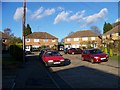
Marvell Close, Pound Hill, Crawley
One of three dead-ends branching off Chaucer Road in this poetic area.
Image: © Robin Webster
Taken: 3 Feb 2021
0.05 miles
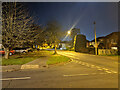
6
Burns Road joins Chaucer Road, Pound Hill, Crawley
Image: © Robin Webster
Taken: 3 Feb 2021
0.06 miles
7
Marvell Close, Pound Hill, Crawley
Typical 1950s and 60s Taylor Woodrow houses.
Image: © Elliott Simpson
Taken: 22 Nov 2007
0.06 miles
10
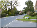
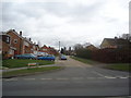
Looking north on Grattons Drive
A different view from 2011 is at http://www.geograph.org.uk/photo/2295787.
Image: © Shazz
Taken: 30 Apr 2016
0.09 miles