IMAGES TAKEN NEAR TO
Dumsday Close, RH10 2AX
Introduction
This page details the photographs taken nearby to Dumsday Close, RH10 2AX by members of the Geograph project.
The Geograph project started in 2005 with the aim of publishing, organising and preserving representative images for every square kilometre of Great Britain, Ireland and the Isle of Man.

There are currently over 7.5m images from over14,400 individuals and you can help contribute to the project by visiting https://www.geograph.org.uk
Image Map (Loading...)


Getting Data...Please wait
Leaflet Map data © OpenStreetMap
Images are licensed for reuse under creativecommons.org/licenses/by-sa/2.0
Notes
- Clicking on the map will re-center to the selected point.
- The higher the marker number, the further away the image location is from the centre of the postcode.
Image Listing (35 Images Found)
Images are licensed for reuse under creativecommons.org/licenses/by-sa/2.0
Image
Details
Distance
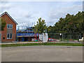
1
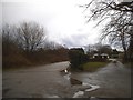
The entrance to Hollybush Business Centre, Copthorne
Image: © David Howard
Taken: 3 Apr 2016
0.04 miles
2

Shipley Bridge Lane
From Copthorne towards Shipley Bridge.
Image: © Robin Webster
Taken: 2 Jul 2019
0.05 miles
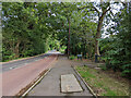
3
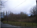
Woods by Shipley Bridge Lane, Copthorne
The verge has been levelled and cleared since 2008, including the removal of a tree by the near telegraph pole on the right edge.
Image: © David Howard
Taken: 3 Apr 2016
0.05 miles
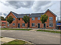
4
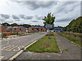
Worsell Drive, Heathy Wood, Copthorne
Now used by Metrobus route 281 as a through route, even though considerable lengths pass through building sites at the moment. The 'Doctors Surgery' sign is a puzzle, presumably in anticipation, as it points into a building site at the moment.
Image: © Robin Webster
Taken: 3 Oct 2022
0.06 miles
5
Worsell Drive, Heathy Wood, Copthorne
Now used by Metrobus route 281 as a through route, even though considerable lengths pass through building sites at the moment.
Image: © Robin Webster
Taken: 3 Oct 2022
0.07 miles
6

Worsell Drive, Heathy Wood, Copthorne
Now used by Metrobus route 281 as a through route, even though considerable lengths pass through building sites at the moment.
Image: © Robin Webster
Taken: 3 Oct 2022
0.07 miles
8
Shipley Bridge Lane, Copthorne
Over this stretch Surrey is on the left of the lane and West Sussex on the right.
Image: © Robin Webster
Taken: 3 Oct 2022
0.08 miles
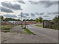
10
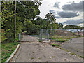
Gated road to pumping station, Copthorne
It also seems to be used as a non-statutory footpath, but it is not clear if there is a through route.
Image: © Robin Webster
Taken: 3 Oct 2022
0.08 miles