IMAGES TAKEN NEAR TO
Punch Copse Road, CRAWLEY, RH10 1RD
Introduction
This page details the photographs taken nearby to Punch Copse Road, RH10 1RD by members of the Geograph project.
The Geograph project started in 2005 with the aim of publishing, organising and preserving representative images for every square kilometre of Great Britain, Ireland and the Isle of Man.

There are currently over 7.5m images from over14,400 individuals and you can help contribute to the project by visiting https://www.geograph.org.uk
Image Map
Images are licensed for reuse under creativecommons.org/licenses/by-sa/2.0
Notes
- Clicking on the map will re-center to the selected point.
- The higher the marker number, the further away the image location is from the centre of the postcode.
Image Listing (53 Images Found)
Images are licensed for reuse under creativecommons.org/licenses/by-sa/2.0
Image
Details
Distance
1
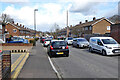
Punch Copse Road, Three Bridges, Crawley
There was once a Punch Copse, mostly beyond the end of this road and to the right, but it has very largely been built over by the New Town.
Image: © Robin Webster
Taken: 13 Mar 2021
0.01 miles
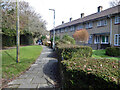
2
Early Commons, Three Bridges, Crawley
Early Commons comprises two short dead-end roads off Punch Copse Road and a path connecting their ends. Odd numbered houses are only on the roads, and even only on the path.
Image: © Robin Webster
Taken: 13 Mar 2021
0.03 miles
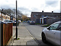
3
Houses on Broomdashers Road, Three Bridges, Crawley
Image: © Robin Webster
Taken: 13 Mar 2021
0.04 miles
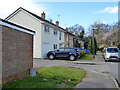
4
Houses on Early Commons, Three Bridges, Crawley
Early Commons comprises two short dead-end roads off Punch Copse Road and a path connecting their ends. Odd numbered houses are only on the roads, and even only on the path.
Image: © Robin Webster
Taken: 13 Mar 2021
0.05 miles
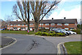
5
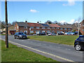
Houses on Punch Copse Road, Three Bridges, Crawley
Looking from Broomdashers Road.
Image: © Robin Webster
Taken: 13 Mar 2021
0.05 miles
6
Houses on Early Commons, Three Bridges, Crawley
Early Commons comprises two short dead-end roads off Punch Copse Road and a path connecting their ends. Odd numbered houses are only on the roads, and even only on the path.
Image: © Robin Webster
Taken: 13 Mar 2021
0.06 miles
7
Broomdashers Road, Three Bridges, Crawley
Image: © Robin Webster
Taken: 13 Mar 2021
0.07 miles
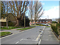
8
A2004 Northgate Avenue, Crawley
Heading out of town towards the M23.
Image: © Robin Webster
Taken: 13 Mar 2021
0.07 miles
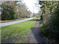
9
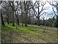
Belt of woodland between Crawter's Brook and Northgate Avenue, Crawley
A foot and cycle way runs up the middle.
Image: © Robin Webster
Taken: 13 Mar 2021
0.08 miles
10
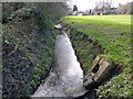
Crawter's Brook, Northgate, Crawley
Looking upstream.
Image: © Robin Webster
Taken: 13 Mar 2021
0.09 miles