IMAGES TAKEN NEAR TO
Kimberley Road, CRAWLEY, RH10 1NG
Introduction
This page details the photographs taken nearby to Kimberley Road, RH10 1NG by members of the Geograph project.
The Geograph project started in 2005 with the aim of publishing, organising and preserving representative images for every square kilometre of Great Britain, Ireland and the Isle of Man.

There are currently over 7.5m images from over14,400 individuals and you can help contribute to the project by visiting https://www.geograph.org.uk
Image Map (153 Images)


Getting Data...Please wait
Leaflet Map data © OpenStreetMap
Images are licensed for reuse under creativecommons.org/licenses/by-sa/2.0
Notes
- Clicking on the map will re-center to the selected point.
- The higher the marker number, the further away the image location is from the centre of the postcode.
Image Listing (153 Images Found)
Images are licensed for reuse under creativecommons.org/licenses/by-sa/2.0
Image
Details
Distance
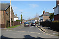
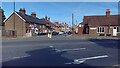
2
Corner houses, Hazelwick Road and Mill Road, Three Bridges, Crawley
Image: © Robin Webster
Taken: 28 Feb 2021
0.07 miles
3
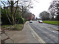
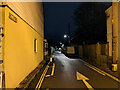
Hazelwick Avenue, Three Bridges, Crawley
A busy major road, but unclassified. On the left footpath 3380 restarts, following the bank of the Gatwick Stream to Haslett Avenue East.
Image: © Robin Webster
Taken: 13 Mar 2021
0.07 miles
4
Beauty salon on Hazelwick Road, Three Bridges, Crawley
The smaller building down Mill Lane is a 'Hair studio'.
Image: © Robin Webster
Taken: 28 Feb 2021
0.08 miles
5
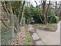
Footpath 3380, Three Bridges, Crawley
Towards Haslett Avenue East beside the Gatwick Stream.
Image: © Robin Webster
Taken: 13 Mar 2021
0.08 miles
6
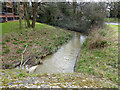
Gatwick Stream at Henson Road bridge, Three Bridges, Crawley
Looking upstream.
Image: © Robin Webster
Taken: 13 Mar 2021
0.09 miles
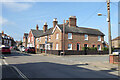
8
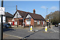
Montefiore Institute, Three Bridges, Crawley
The Montefiore Institute was built in 1896 by the Montefiore family for the use of Worth Park Estate workers. In 1931 the hall was passed to the village of Three Bridges for their use. The public inquiry into whether Crawley should be designated a New Town (under the New Towns Act 1946) was held here on 4–6 November 1946.
Image: © Robin Webster
Taken: 28 Feb 2021
0.09 miles
9
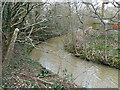
Gatwick Stream looking downstream
From footpath 3380.
Image: © Robin Webster
Taken: 13 Mar 2021
0.09 miles
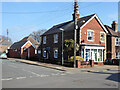
10
Mill Road, Three Bridges, Crawley
One of a few residential roads near Three Bridges station from before new town developments. The mill, Hazelwick Mill, is long gone. It was on what is now called the Gatwick Stream about where the Tesco fuel station is now.
Image: © Robin Webster
Taken: 24 Jan 2021
0.09 miles