IMAGES TAKEN NEAR TO
Englefield, READING, RG7 5JT
Introduction
This page details the photographs taken nearby to RG7 5JT by members of the Geograph project.
The Geograph project started in 2005 with the aim of publishing, organising and preserving representative images for every square kilometre of Great Britain, Ireland and the Isle of Man.

There are currently over 7.5m images from over14,400 individuals and you can help contribute to the project by visiting https://www.geograph.org.uk
Image Map
Images are licensed for reuse under creativecommons.org/licenses/by-sa/2.0
Notes
- Clicking on the map will re-center to the selected point.
- The higher the marker number, the further away the image location is from the centre of the postcode.
Image Listing (2 Images Found)
Images are licensed for reuse under creativecommons.org/licenses/by-sa/2.0
Image
Details
Distance
1
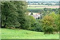
Mayridge Farm
Taken from the bend in the bridleway, 30 metres higher up the hillside.
Image: © Graham Horn
Taken: 29 Sep 2008
0.05 miles
2
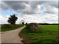
Branch Road off Bostock Lane: Near Englefield
The end of the land as it meets the lane running north east and south west across the north eastern quadrant of the grid square. The picture was taken looking south east.
Image: © Pam Brophy
Taken: 14 Apr 2005
0.12 miles