IMAGES TAKEN NEAR TO
Sorrel Close, READING, RG7 3YS
Introduction
This page details the photographs taken nearby to Sorrel Close, RG7 3YS by members of the Geograph project.
The Geograph project started in 2005 with the aim of publishing, organising and preserving representative images for every square kilometre of Great Britain, Ireland and the Isle of Man.

There are currently over 7.5m images from over14,400 individuals and you can help contribute to the project by visiting https://www.geograph.org.uk
Image Map
Images are licensed for reuse under creativecommons.org/licenses/by-sa/2.0
Notes
- Clicking on the map will re-center to the selected point.
- The higher the marker number, the further away the image location is from the centre of the postcode.
Image Listing (31 Images Found)
Images are licensed for reuse under creativecommons.org/licenses/by-sa/2.0
Image
Details
Distance
7
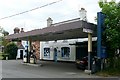
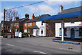
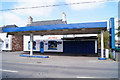
Garage on Reading Road
One of the first generation of covered forecourts, still run independently, before the big three oil companies started building their mega-forecourts.
Image: © Graham Horn
Taken: 13 Jun 2009
0.10 miles
8
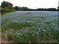
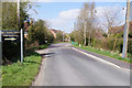
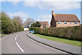
Crop near Burghfield
This field is in the south western section of the square. The view is on a bearing of more or less north west along the road.
Image: © Pam Brophy
Taken: 1 Jul 2005
0.10 miles
9
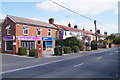
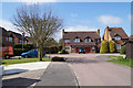
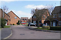
Designed to stand out
The colour does not suggest properties with style for sale. But then who am I to comment!
Image: © Fernweh
Taken: 22 Apr 2013
0.10 miles